
Bristol City Centre Transport Changes
Bristol city centre is set to change in the coming years, with major new housing developments and leisure and retail facilities planned. This will help the city tackle its housing crisis and sustain the vitality of the central area.
To prepare for around 5,000 more people living in and travelling around Broadmead, Bristol City Council is proposing changes to transform some public spaces and surrounding roads to make the city centre more welcoming and people-friendly.
These changes would improve walking, wheeling and cycling routes, benefit existing bus services, and support the long-term goal of creating a segregated rapid transit route between the southwest and the northeast of the city, travelling via the city centre.
The council ran the Bristol City Centre Transport Changes consultation from 12 August to 30 September 2024 so everyone could find out more about the plans and give their views.
Public consultation results
We have published a summary of the responses to the public consultation held in the summer 2024.
It sets out how we promoted the consultation and gives an overview of the feedback we received.
Download the engagement report summary.
The full engagement report will be available in early 2025.
Why are we proposing changes to the city centre?
Bristol City Centre Development and Delivery Plan sets out a vision for the regeneration of the city centre, focusing on Broadmead and Castle Park. It plans for 2,500 more homes, as well as new student and co-living accommodation, offices, shops and leisure facilities in the centre. There could be up to 5,000 new residents in an area where currently 1,400 residents live.
Our vision for the Broadmead area is to create an inclusive, sustainable and re-connected place for everybody. A place of diverse retail with vibrant cultural facilities and a thriving evening economy, while at the same time being somewhere to call home.
With more people in the city centre, we want to make more traffic-free space for them, improve streets, public transport, and active travel as well as tackle air pollution and carbon emissions.
The changes we are proposing in the city centre would enable people to switch from car journeys to more sustainable public transport and active travel options, including walking, wheeling and cycling. This in turn would help us to work towards net zero while giving people all the health and wellbeing benefits of more physical activity.
Our 2024 consultation does not seek feedback on the Bristol City Centre Development and Delivery Plan as this has been consulted on already and has been adopted by Bristol City Council.
Areas covered
In this consultation, we are proposing changes in five areas:
- Broadmead area
- Bedminster Bridges
- Redcliffe Roundabout
- Temple Way
- Bond Street
Across these five areas, plans include changes to public spaces in the Broadmead area, along with changes to bus routes and bus infrastructure, and proposals to make walking, wheeling and cycling safer and easier across all five locations.
Funding
The Bristol City Centre Transport Changes programme is being funded by the government as part of the City Region Sustainable Transport Settlement, which is administered by the West of England Combined Authority.
Proposals
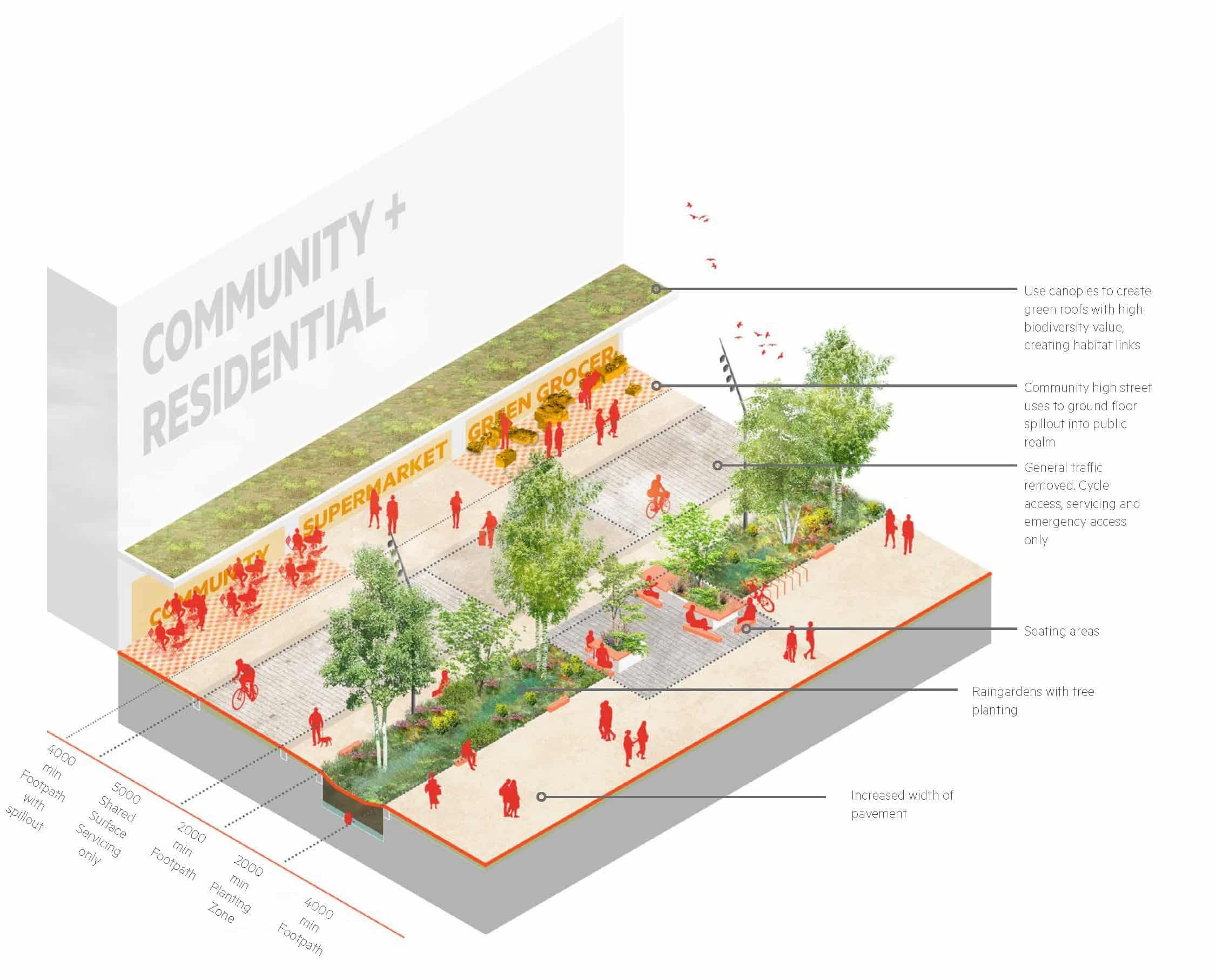
Proposals to change public spaces in the Broadmead area include:
- pedestrianising The Horsefair and Penn Street, with access for emergency vehicles and deliveries for businesses allowed at set times when the streets are less busy
- removing most of the traffic from Union Street, making it two-way for buses and cycles
- introducing about 10 tennis courts worth of new traffic-free space, with more landscaping, seating and art space
Proposals to bus routes and bus infrastructure include:
- changes to road layouts that would make it possible to operate a rapid transit route running north to south via Union Street
- changing the routes some buses take through the city centre to avoid the pedestrianised streets
- removing buses that have terminated and stand empty for long periods of time from pedestrian and shopping areas
- adding bus priority measures, including bus gates and bus lanes across the five areas
- closing bus stops on The Horsefair, Penn Street and Union Street and introducing new bus stops on Union Street and Fairfax Street
Proposals to make walking, wheeling and cycling safer and easier across all five areas include:
- creating more than 3.5km of new segregated cycle routes and joining up gaps in the cycle network
- reducing traffic and changing road layouts
- widening pavements and simplifying pedestrian and cycle crossings
A new rapid transit route running north to south
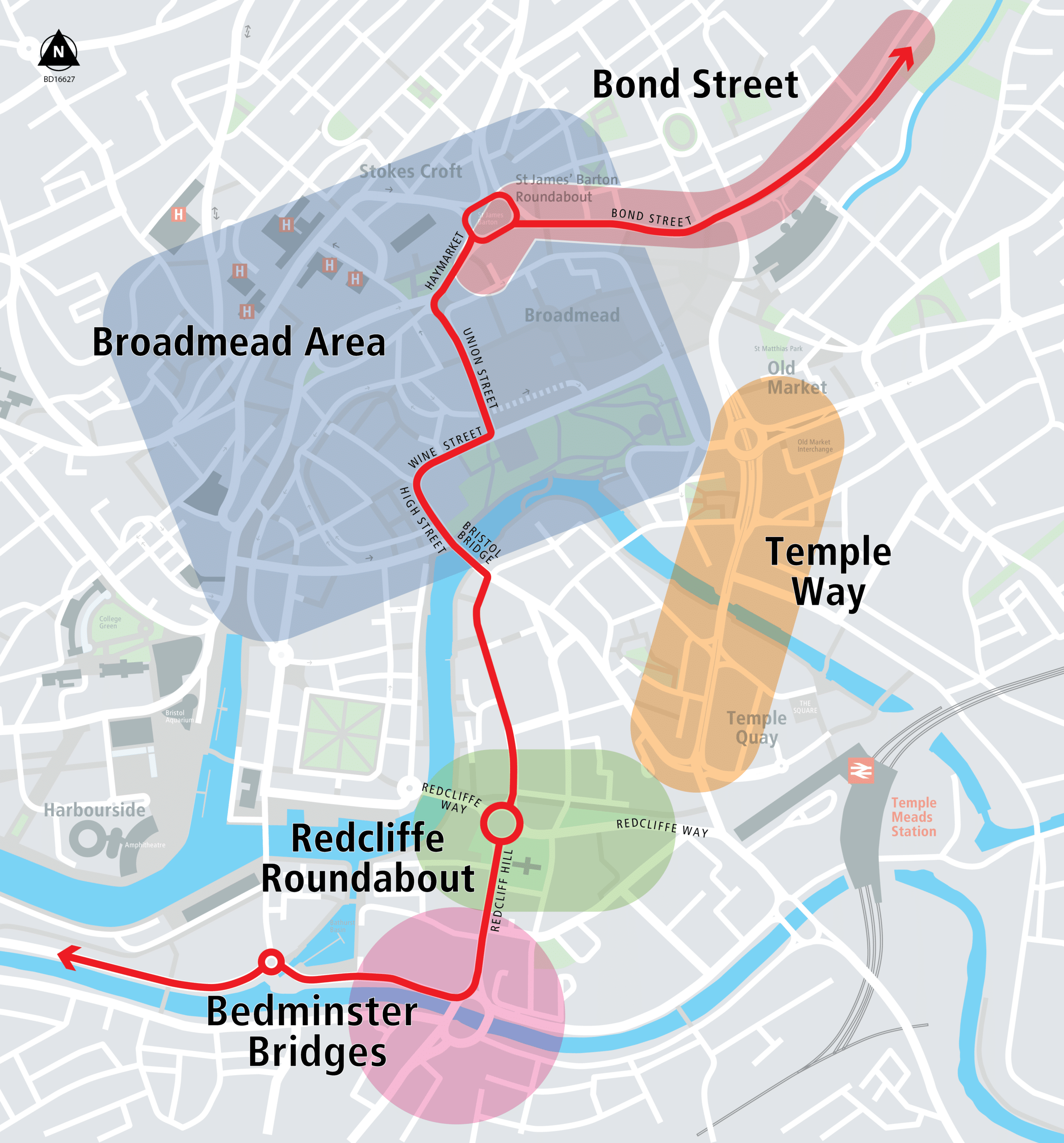
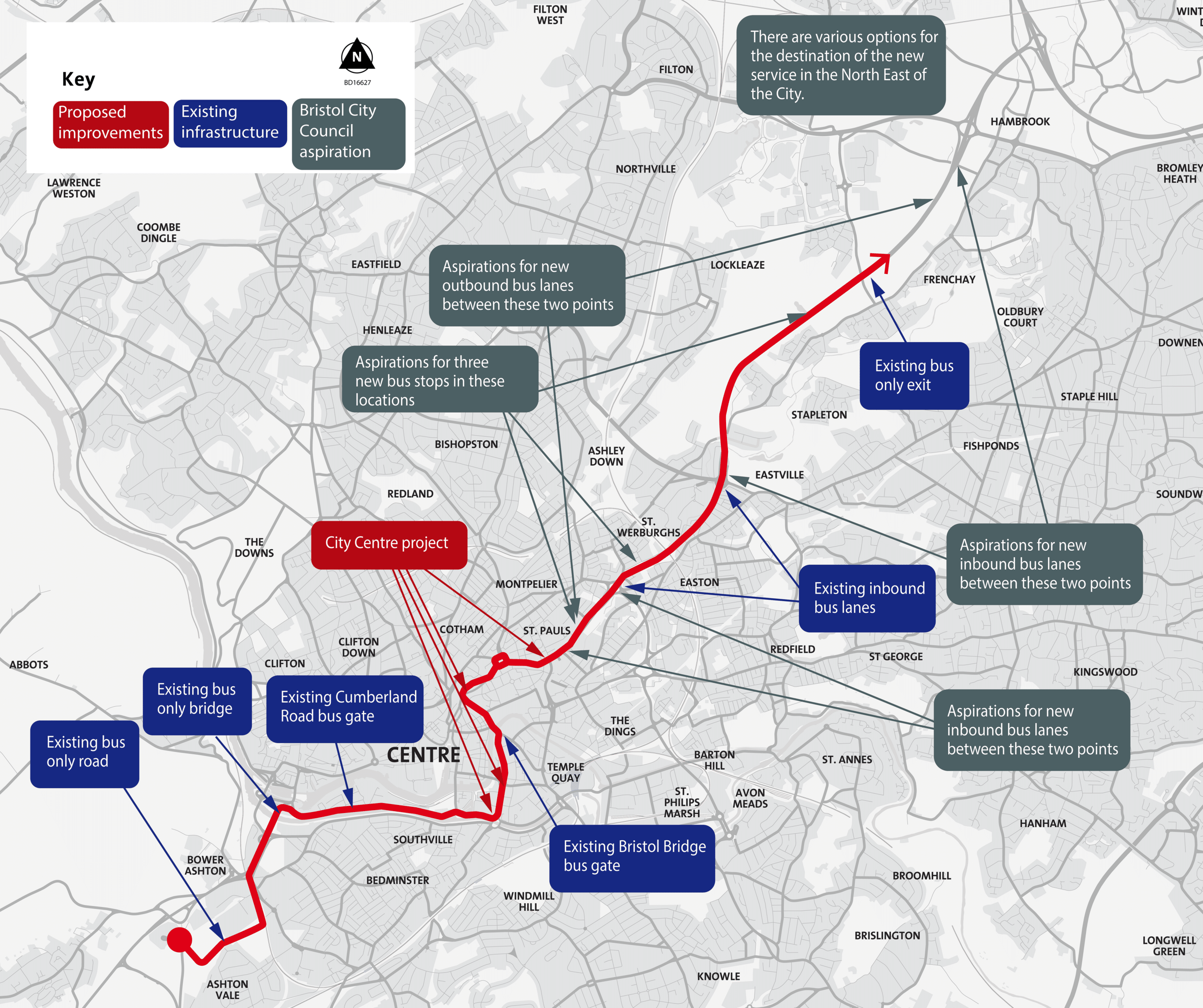
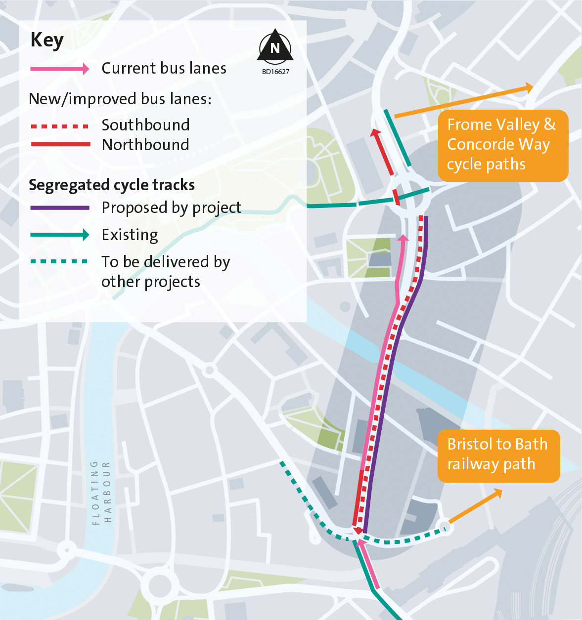
We are proposing changes to roads that would make it possible to operate a new rapid transit route running from the southwest to the northeast of the city via Bristol city centre. This is part of a larger ambition for a rapid transit network of fast, frequent, reliable, high-quality services running across the city.
Between the southwest and centre, we have been implementing other bus priority measures which rapid transit services would benefit from (the blue boxes in the graphic show the proposed route the rapid transit service would take).
In the central area, the route isn’t currently physically possible. This project would do that and would make the route faster. The route would connect Commercial Road to Newfoundland Circus via Redcliff Hill, Redcliffe Street, Bristol Bridge, Union Street and The Haymarket. This project provides priority and faster journey times for the new service with new bus lanes, bus gates, a two-way bus-only route on Union Street and new bus-only junctions.
From the centre to the northeast, the council has an aspiration for new stops and bus priority measures on the M32. The service could start/end at a new park & ride on the M32 or other destinations in the north fringe in the interim for example UWE or Emersons Green.
The below graphic shows the proposed route the new rapid transit service would take as well as existing priority infrastructure, infrastructure to be implemented as part of this project, and the council’s aspirations for future changes:
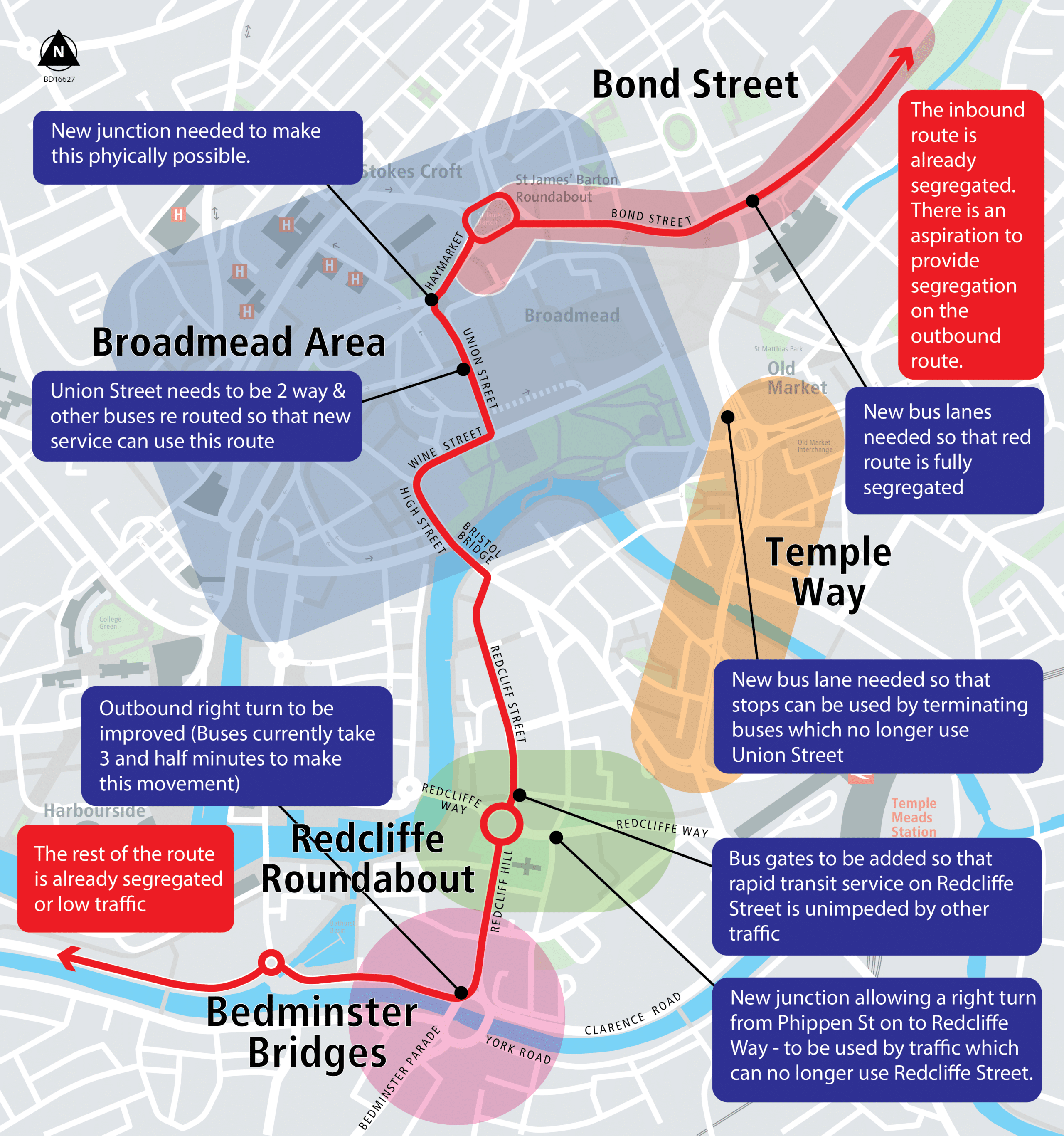
This graphic shows the changes in the city centre and how they will benefit the aspiration of a new rapid transit service:
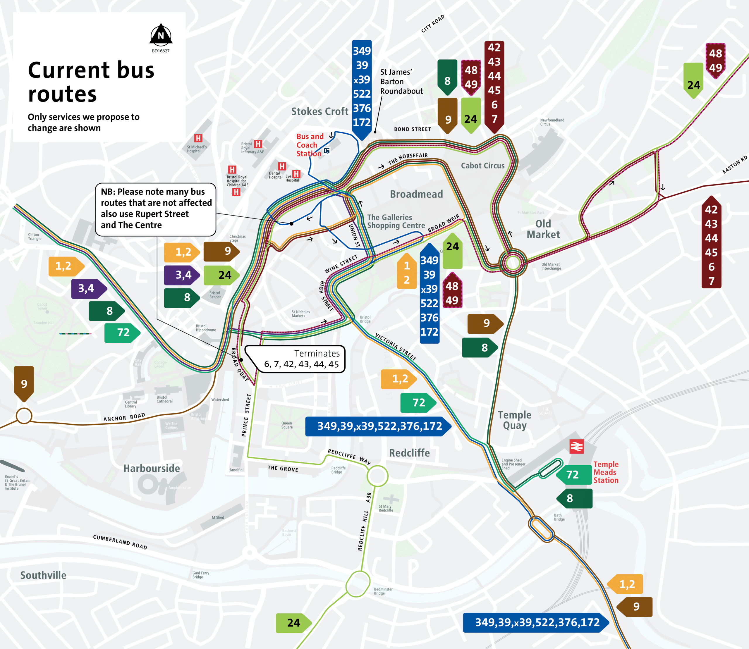
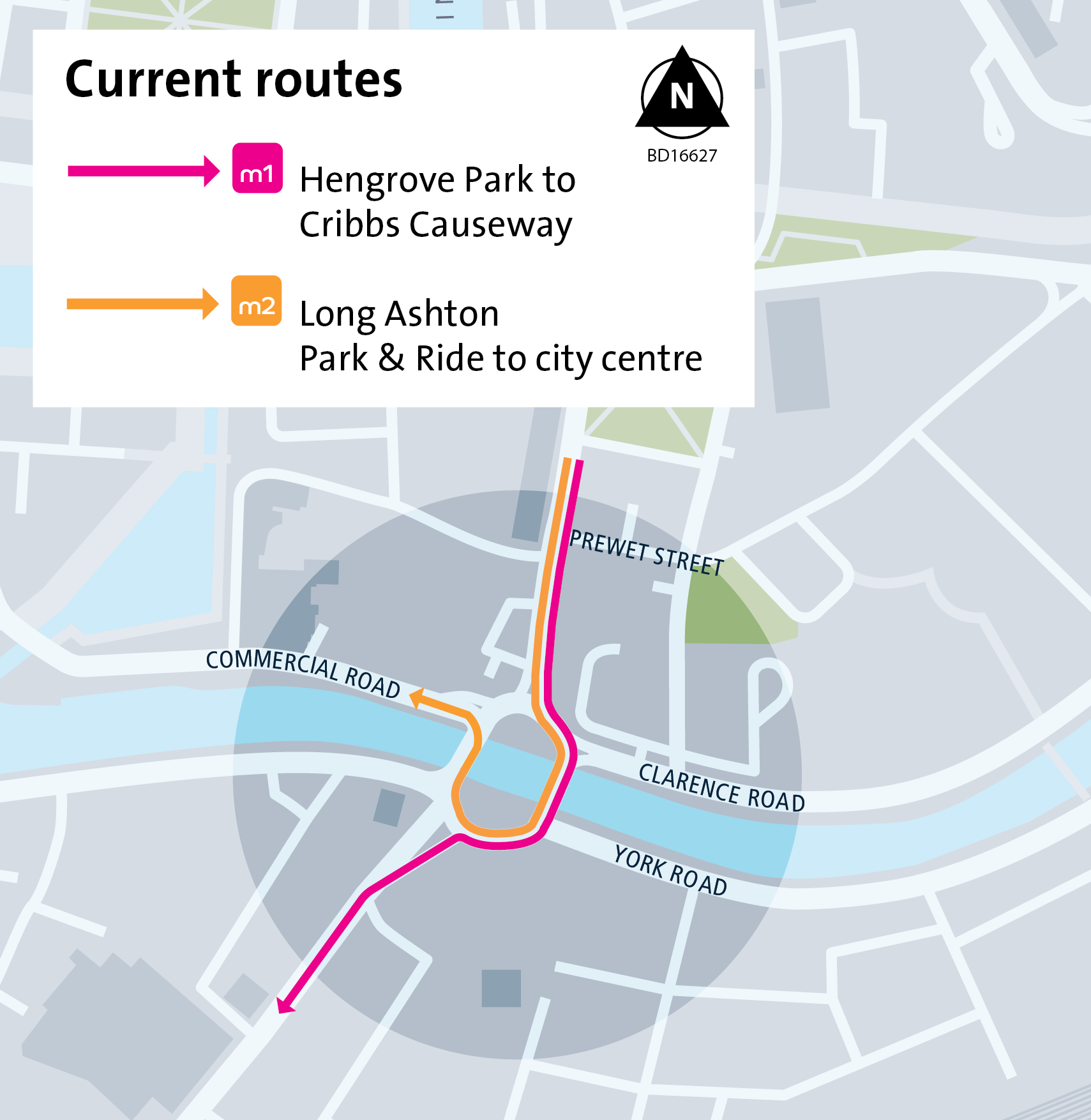
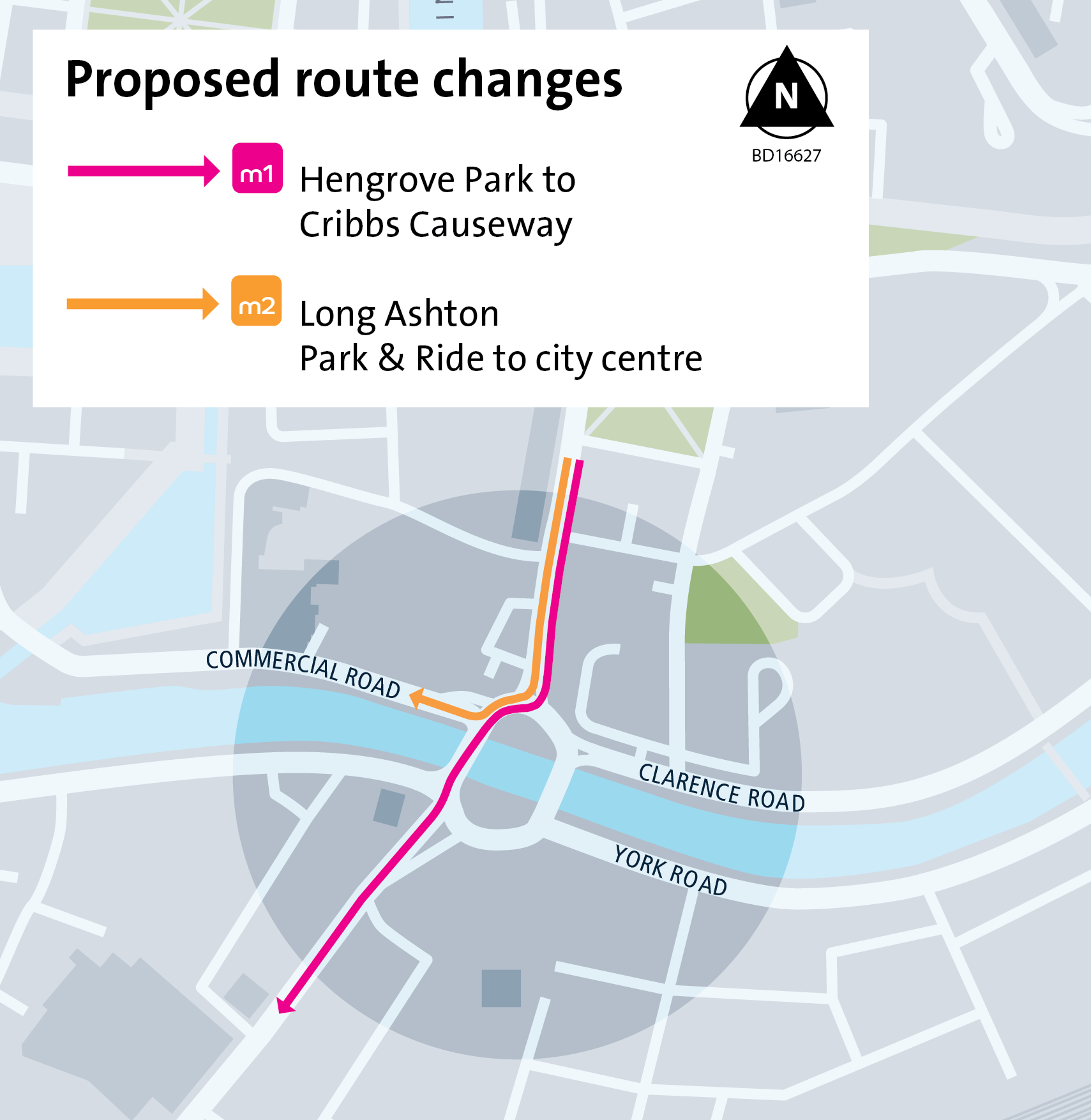
Re-routing of bus services around Broadmead
We are proposing re-routing a number of buses. Most of these are ones which travel east to west between Nelson Street and Old Market along The Horsefair. This would allow us to pedestrianise and improve the public spaces in more of the Broadmead area.
We would re-route buses that use The Horsefair and Penn Street via Fairfax Street and Broad Weir alongside Castle Park. As part of The Galleries redevelopment, Fairfax Street is going to be made wider, brighter, lighter and have shop and office fronts. It will also have a mobility hub and public access lifts from Fairfax Street to Broadmead.
We would re-route some other bus services that use Baldwin Street and/or Victoria Street to take advantage of the proposed changes to road layouts in the Broadmead area.
We are also proposing relocating where buses wait when they terminate from the Broadmead area to Temple Way, so they do not stand empty for long periods of time in busy pedestrian and shopping areas.
The two maps below show the current routes of affected services and the proposed routes of affected services:
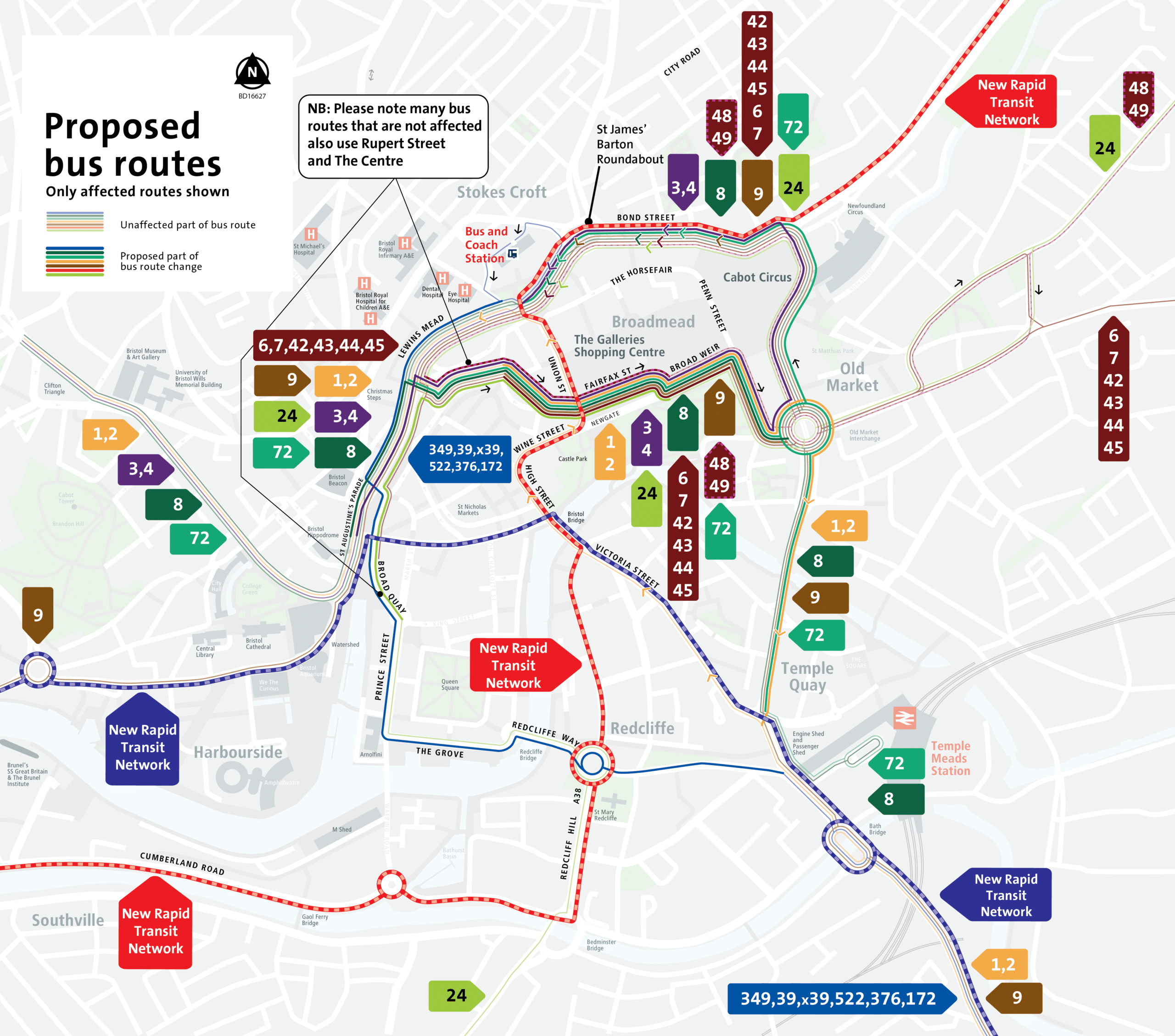
Detailed description of proposed bus route and stop changes
-
See a full list of current bus stops.
Only the section of the route where changes are proposed are listed.
Services with no changes
- 13, 25, 462, m1, m3, m3x, m4, T1, 70, 73, 74, 75, 76, T1, Y6, u3, 3X, A1
- Free hospital service
- Scheduled coaches, including National Express, Falcon & Flix
- North Somerset services (X1, X4, X6, X7, X8, X9 and U2)
- 48X and 49X
-
9 eastbound (Portway Park & Ride to Brislington Park & Ride):
- Current route via Nelson Street, The Horsefair, Penn Street and Lower Castle Street (bus stops Anchor Road (A2), The Centre (C8), Broadmead, The Horsefair (B13), Penn Street (S7), and Temple Way (M1))
- Proposed route via Nelson Street, Fairfax Street, Broadweir and Lower Castle Street (bus stops Anchor Road (A2), The Centre (C8), Fairfax Street (new stop) and Temple Way (M1))
- 9 westbound would be unchanged via Bond Street South, Bond Street, Rupert Street and The Centre
42, 43, 44, 45, 6, 7 eastbound (Centre to East Bristol):
- Current route via Nelson Street, The Horsefair, Penn Street and Lower Castle Street (bus stops Nelson Street (B5), The Horsefair (B13), Penn Street (S11), Old Market Str (M3), Lamb Street (NE-bound))
- Proposed route via Nelson Street, Fairfax Street, Broadweir and Lower Castle Street (bus stops Nelson Street (B5), Broad Weir (S12), Old Market Str (M3), Lamb Street (NE-bound))
- 42, 43, 44, 45, 6, 7 westbound services would be unchanged via Bond Street South, Bond Street, Rupert Street and The Centre
8 eastbound (Clifton to Temple Meads station):
- Current route via Baldwin Street, Wine Street, Union Street, The Horsefair, Penn Street and Lower Castle Street (bus stops: College Green (P2), Baldwin Street (C13), Wine Street (B17), The Horsefair (B15), Penn Street (S7) and Temple Way (M1))
- Proposed route via Nelson Street, Fairfax Street, Broadweir and Lower Castle Street (bus stops: College Green (P2), Nelson Street (B5), Fairfax (new stop), Broad Weir (S12), and Temple Way (M1))
- 8 westbound would be unchanged via Bond Street South, Bond Street, Rupert Street and The Centre
1 and 2 southbound (Cribbs Causeway to Broomhill / Stockwood):
- Current route via Nelson Street, The Horsefair, Penn Street, Broad Weir, Deansgate, Wine Street and Victoria Street (bus stops: The Centre (C8), The Horsefair (B11), Broad Weir (S10), Wine Street (B18), Bristol Bridge (R9), Victoria Street (R7), and Temple Meads Stn (T1))
- Proposed route via Nelson Street, Fairfax Street, Broadweir, Lower Castle Street and Temple Way (bus stops: The Centre (C8), Fairfax Street (new stop), Lower Castle Street (new stop), Temple Way (M1), Temple Way (T9) and Temple Meads Stn (T1))
- 1 and 2 northbound services would be unchanged via Victoria Street, Bristol Bridge, Union Street, Rupert Street and the Centre
-
72 southbound (UWE to Temple Meads station):
- Current route via Baldwin Street and Victoria Street (bus stops College Green (P2), Baldwin Street (C13), Baldwin Street (R11), Bristol Bridge (R9)
- Victoria Street (R7), and Temple Meads station forecourt (T6))
- Proposed route via Nelson Street, Fairfax Street, Broadweir, and Temple Way (bus stops: College Green (P2), Nelson Street (B5), Fairfax (new stop), Broad Weir (S12), Temple Way (M1), Temple Way (T9) and Temple Meads station forecourt (T6)
72 northbound (Temple Meads station to UWE ):
- Current route via Victoria Street, Bristol Bridge, Union Street, Rupert Street and the Centre (bus stops: Temple Meads Station forecourt (T6), Victoria Street (T7), Victoria Street (R6), Bristol Bridge (R8), Union Street (B12), and The Centre (C7))
- Proposed roue via Temple Way, Bond Street South, Bond Street, Rupert Street and The Centre (bus stops: Temple Meads Station forecourt (T6), Temple Way (M2), Cabot Circus South (S14), Bond Street (S8) and The Centre (C7))
24 northbound (Ashton Vale to Southmead):
- Current route via Marsh Street, Baldwin Street, Wine Street, Newgate, Broadweir and Lower Castle Street (Bus stops: Redcliff Hill (R2), Baldwin Street (C13), Baldwin Street (R11), Wine Street (B17), Broad Weir (S12), and Old Market Street (M3))
- Proposed route via The Centre, Nelson Street, Fairfax Street, Broadweir and Lower Castle Street (bus stops: Redcliff Hill (R2), The Centre (C4), Nelson Street (C5), Fairfax Street (new stop), Broad Weir (S12), Old Market Streete (M3))
- 24 southbound would be unchanged via Bond Street South, Bond Street, Rupert Street and The Centre
3 and 4 southbound (Cribbs Causeway to The Centre):
- Current route via Baldwin Street, Wine Street, Union Street (bus stops College Green (P2), Baldwin Street (C13), and Union Street (B14))
- Proposed route via Nelson Street, Fairfax Street and Broadweir (bus stops: College Green (P2), St Augustines Parade (C8), Fairfax (new stop) and Cabot Circus South (S14))
3 and 4 northbound (Centre to Cribbs Causeway)
- Current route via Union Street, Rupert Street and the Centre (bus stops Union Street (B12), The Centre (C7), and College Green (P1))
- Proposed route via Lower Castle Street, Bond Street South, Bond Street, Rupert Street and the Centre (bus stops Fairfax (new stop), Cabot Circus South (S14), Bond Street (S6/8) OR Haymarket (B8/B10), St Augustines Parade (C7) and College Green (P1))
Routes 48 and 49 eastbound (Centre to East Bristol)
- Current route starts at The Centre, and goes via Baldwin Street, Wine Street, Newgate, Broadweir, Lower Castle Street, Old Market (Bus stops The Centre (C9), Baldwin Street (R11), Wine Street (B17), Broad Weir (S12), Old Market Street (M3))
- Proposed route would start on Rupert Street and go via Nelson Street, Fairfax Street, Broadweir, Lower Castle Street, Old Market (bus stops: Rupert Street (B4 or B6), Nelson Street, (B5), Broad Weir (S12), Old Market Street (M3))
- 48 and 49 westbound (East Bristol to Centre) follow the existing route via Bond Street South, Bond Street, and Rupert Street but then terminate on Rupert Street instead of continuing to The Centre.
-
Routes 349, 39 & x39, 522, 376, 172 southbound (Bristol to Keynsham/Bath)
- Existing route via Lower Maudlin Street, Bridewell Street, Fairfax Street, Newgate, Wine Street, Bristol Bridge, Victoria Street, Temple Meads Station (bus stops: Bus Station, Wine Street (B18), Bristol Bridge (R9), Victoria Street (R7) and Temple Meads station (T1))
- Proposed route via Lower Maudlin Street, Rupert Street, The Centre, Broad Quay, Prince Street, The Grove, Redcliffe Way, Temple Meads Station (bus stops: Bus Station, The Centre (C3 or C5) and Temple Meads station (T1))
Routes 349, 39 & x39, 522, 376, 172 northbound (Keynsham/Bath to Bristol)
- Existing route via Temple Meads station, Victoria Street, Bristol Bridge, Wine Street, Union Street, Bridewell Street, Lewins Mead, The Haymarket, Marlborough Street, bus station (bus stops: Totterdown Bridge (W-bound), Temple Meads station (T2), Victoria Street (R6), Bristol Bridge (R8), Wine Street (B17), and the Bus Station)
- Proposed route via Temple Meads station (bus stop on Redcliffe Way), Redcliffe Way, The Grove, Prince Street, Broad Key, The Centre, Lewins Mead, The Haymarket, Marlborough Street, Bus Station (bus stops: Totterdown Bridge (W-bound), Temple Meads station (T4), The Centre (C4 or C6) and the Bus Station)
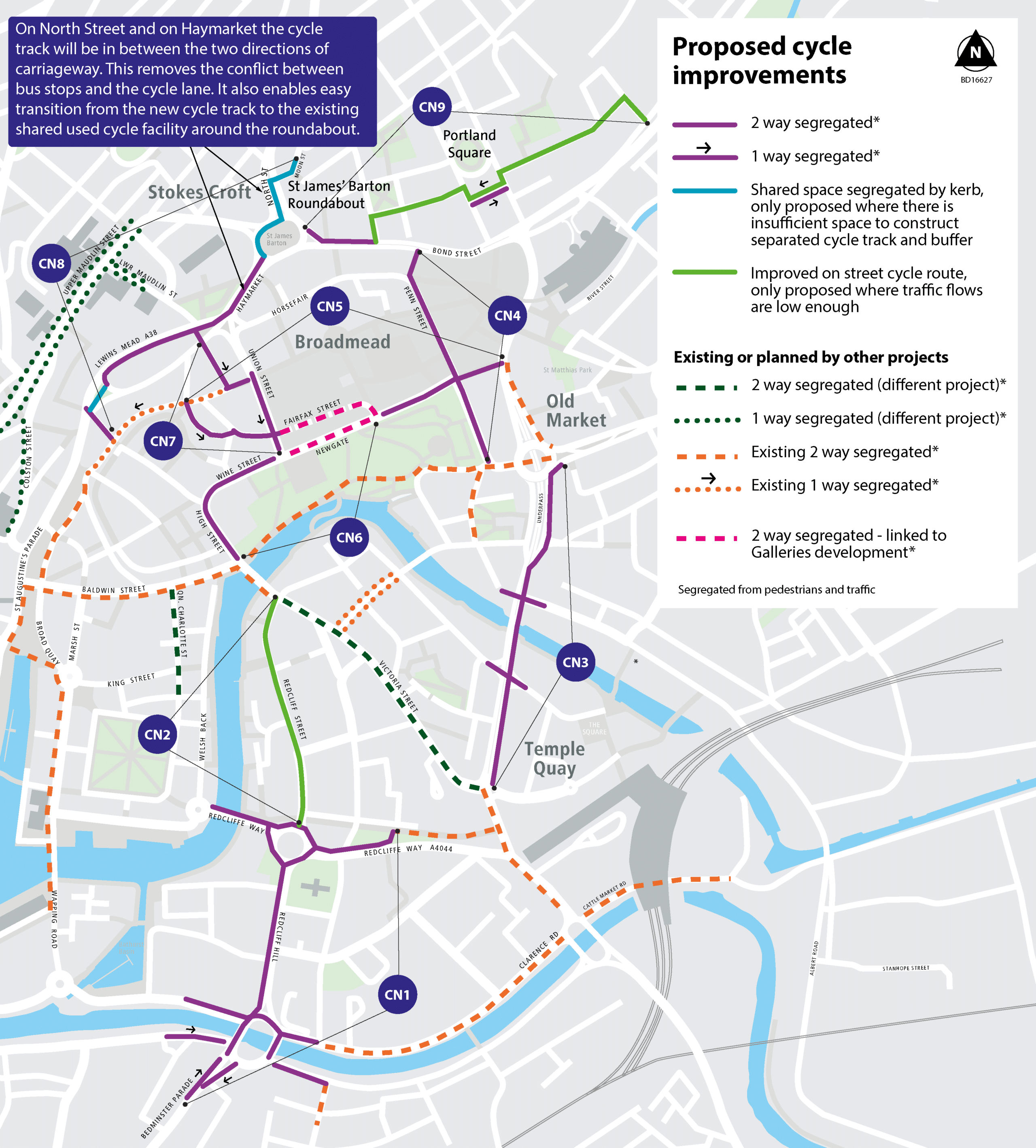
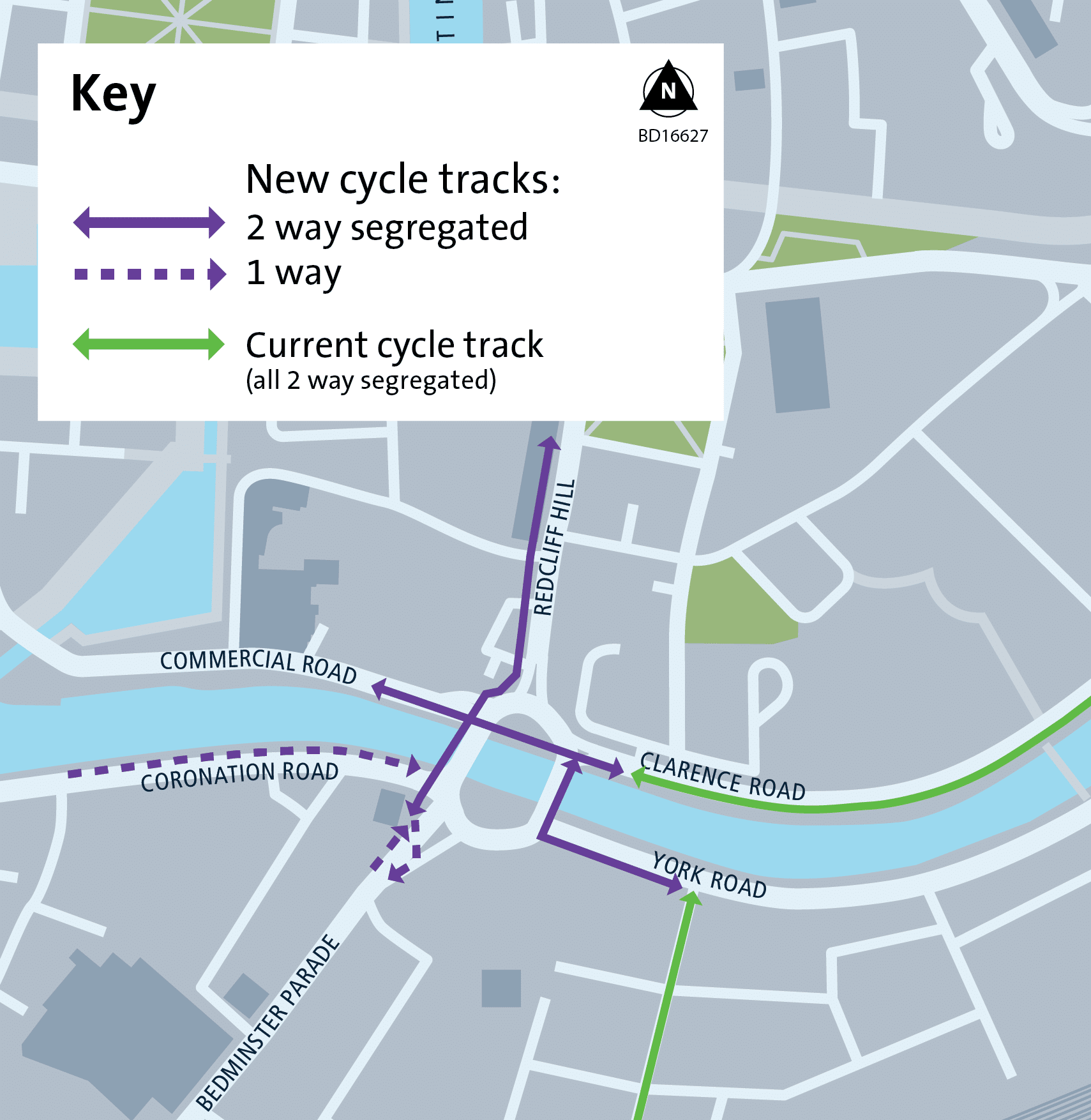
Cycle network
We are proposing cycling improvements in the Broadmead, Bedminster Bridges, Redcliffe Roundabout, Temple Way and Bond Street areas, which would connect existing and proposed sections of the cycle network.
Most of the proposed cycling improvements are cycle tracks, which give cyclists separation from pedestrians and motor vehicles and would make it easier and more pleasant to cycle to and through the city centre. In total, there are 3.5km of new segregated cycle tracks.
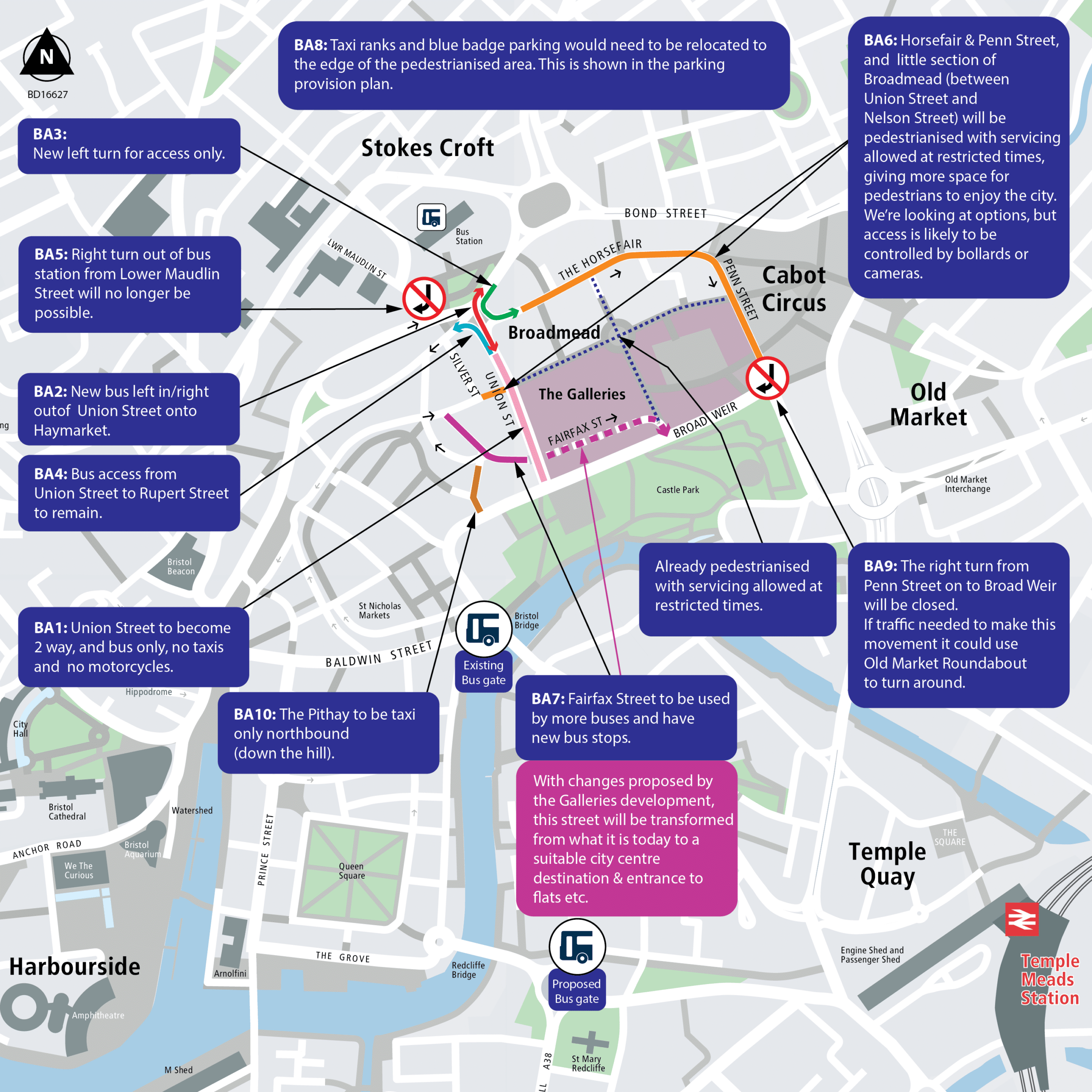
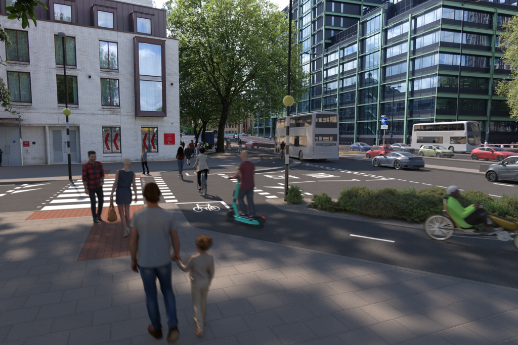
Changes to the Broadmead area
We are proposing pedestrianising The Horsefair and Penn Street with a new access point from Haymarket on The Horsefair. Only essential vehicles and deliveries for businesses would be allowed and only at times when the streets are less busy. This would mean relocating taxi ranks, blue badge parking and loading bays. The amount of taxi ranks and blue badge parking numbers would remain the same.
It would also be necessary to close bus stops on The Horsefair and Penn Street and to change stops on Union Street. A new bus stop would be introduced on Fairfax Street.
For the bus services which used to stop at closed stops, we have proposals for where each bus would now go and where they would stop. These proposals mean that buses, which would have been within a five-minute walk of Broadmead or Baldwin Street, would still be within less than a five-minute walk.
The changes would allow room to introduce more landscaping, seating and art spaces.
The changes are described in the following plans:
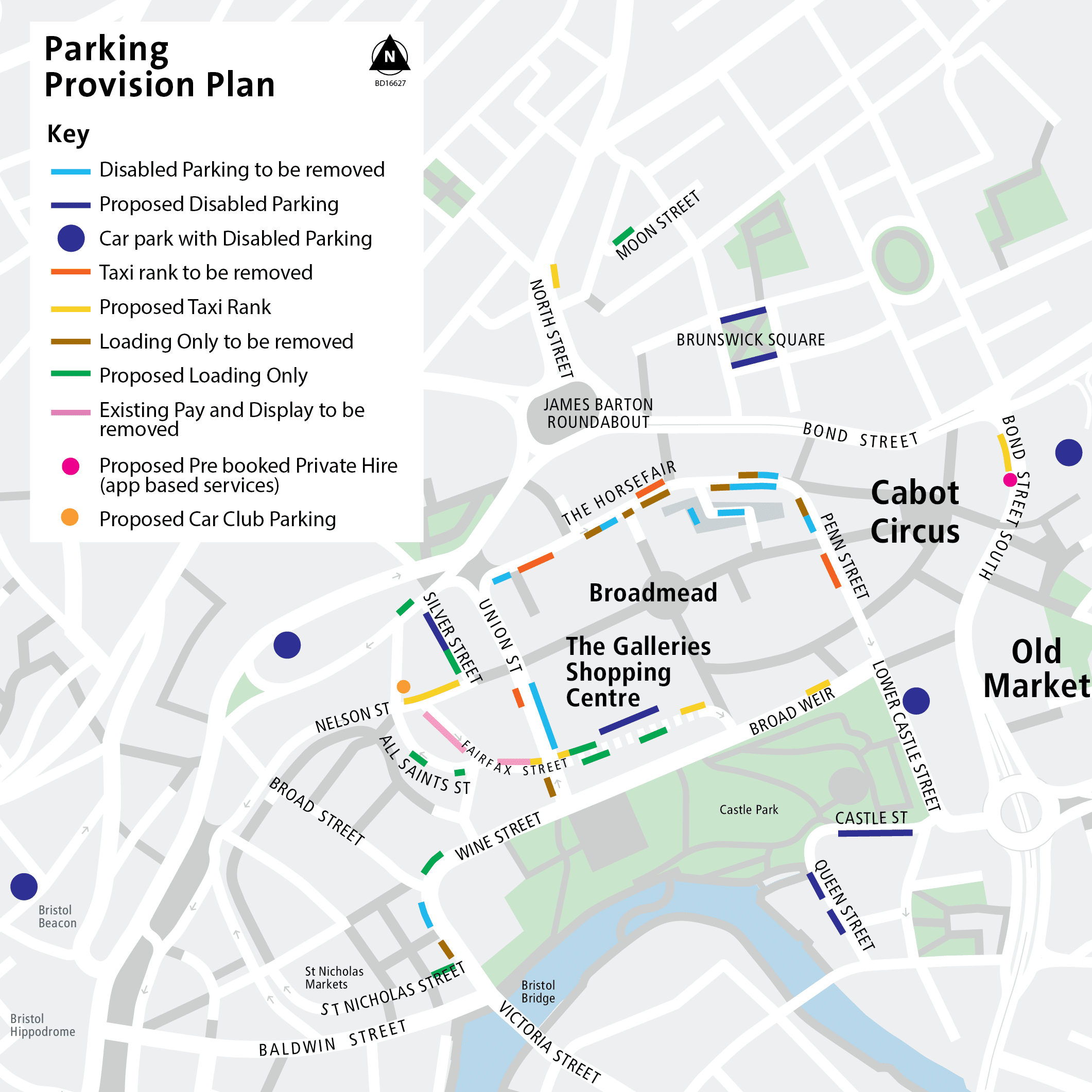
Proposed changes to parking provision:
- 47 disabled parking spaces would be closed and 47 new spaces opened. When The Galleries development is built, this will provide an additional 20 disabled parking spaces bringing the total to 67
- 4 taxi ranks which provide space for 16 taxis would be closed, 4 new ranks with space for 17 taxis would be introduced. When The Galleries development is built, this will provide an additional 2 ranks with space for 8 taxis bringing the total to 25
- to enable the new disabled parking, taxi ranks and cycle lanes we need to close 74 pay and display spaces
- close 8 loading bays, which have space for 20 vehicles, and introduce 7 new bays with space for 12 vehicles. The Galleries development will also introduce new loading only bays
The below image is a visualisation of what Horsefair may look like in the future, this is taken from the City Centre Development And Delivery Plan.
Changes to road layouts in four areas
In addition to the changes in the Broadmead area, we are proposing changes to road layouts in four other areas to further improve bus priority and improve the cycle network.
The four areas are:
- Bedminster Bridges (including East Street, Bedminster Parade and Redcliffe Hill)
- Redcliffe Roundabout (including Redcliffe Way)
- Bond Street (including Newfoundland Circus)
- Temple Way
The proposed changes in these four areas would improve bus journey times and reliability, enable terminating buses to wait away from the Broadmead area and make walking, wheeling and cycling journeys safer and more pleasant.
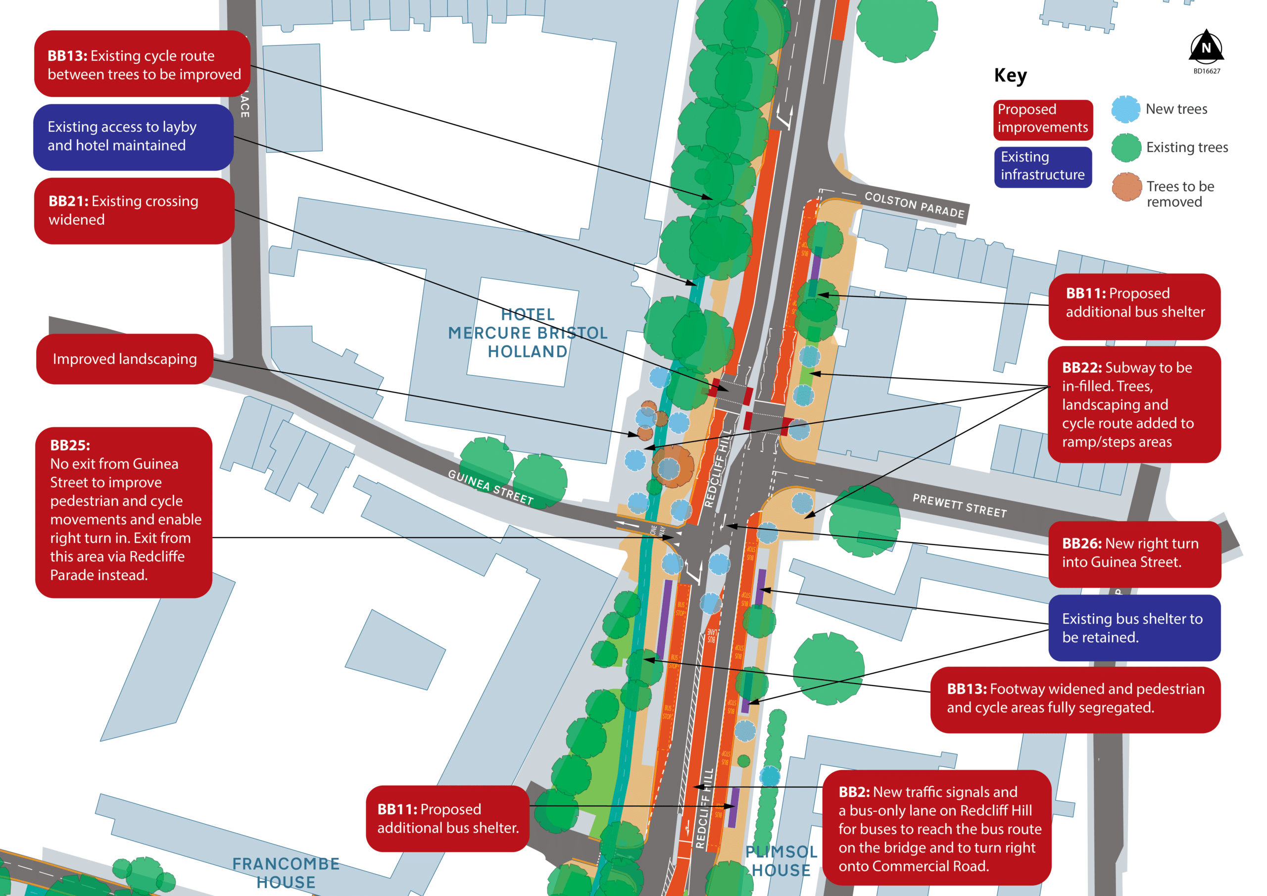
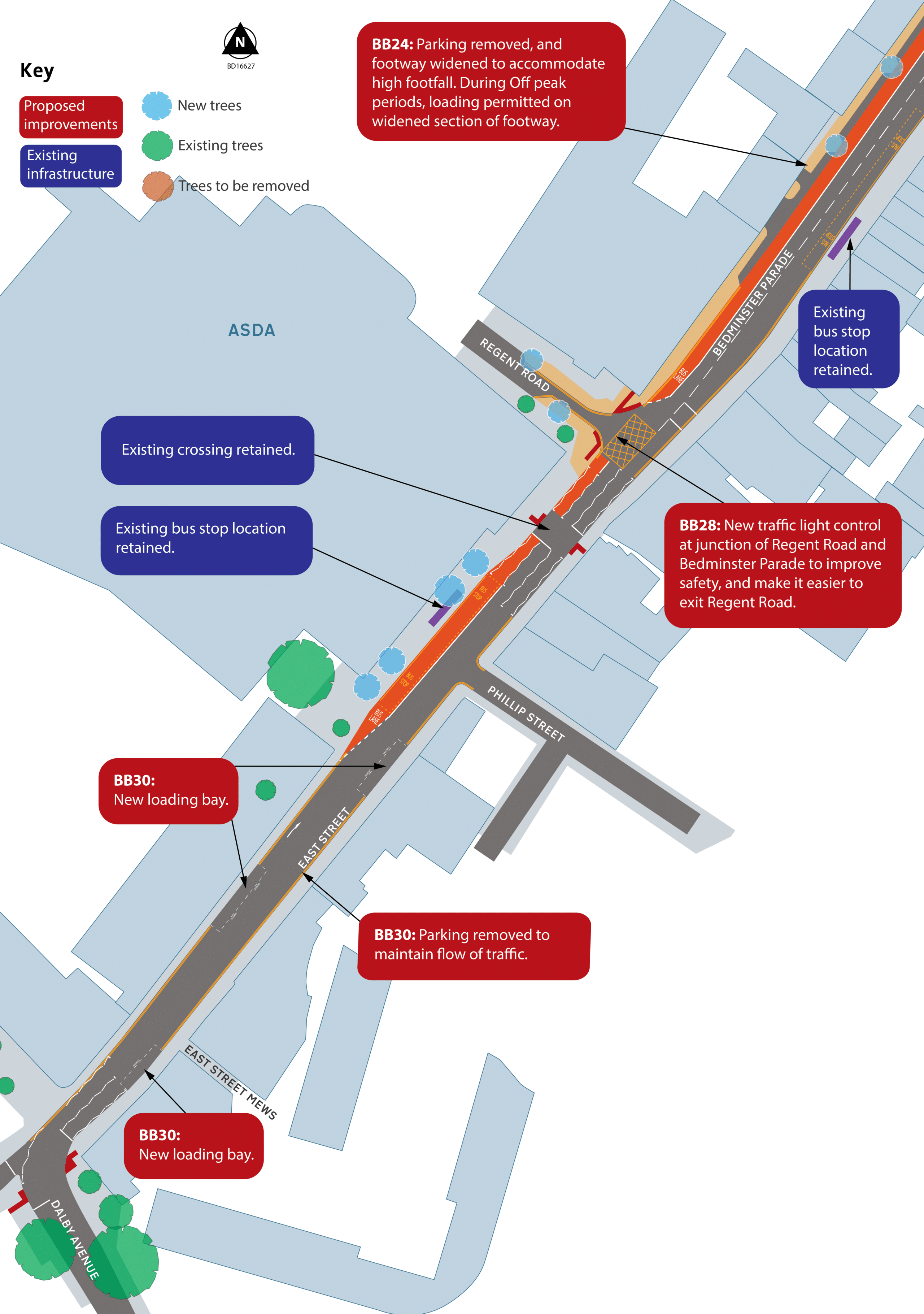
Bedminster Bridges
We are proposing a series of changes to the Bedminster Bridges Roundabout, including East Street, Bedminster Parade and Redcliffe Hill.
The proposals include removing the roundabout and instead making each bridge two-way: one for buses only and one for general traffic.
Buses and cycles would be able to use separate, segregated lanes, which are safer and would mean they are not delayed by other traffic.
Pedestrians would benefit from quicker crossings over the road and more space on the pavement.
High-quality material would be used to reinforce the important gateway from Bedminster, Southville and all of south Bristol to the city centre.
Proposals include:
- introducing dedicated bus-only lanes, separate from other traffic
- installing segregated cycle routes through the area that join up to existing routes
- rationalising the number of pedestrian crossings, meaning pedestrians would only need to cross two roads to get north-south instead of the current four
- improving the public realm, using higher-quality materials and refreshing planting areas
- removing Redcliffe Hill underpass and creating new public spaces in these areas
- improving the existing cycle route over Redcliffe Hill
- increasing the width of the pavement along the west side of Bedminster Parade
- planting new trees – a small number of trees will need to be removed to make way for the new layout, but these would be replaced and even more would be planted
- improving drainage in the area
- replacing the out-of-date traffic signalling equipment
- changing loading arrangements in some areas
- changing some general traffic movements to allow improvements for bus, cycle, and pedestrian routes
The images below show how bus journeys through the junction would change following the proposals:
The route the m2 takes is also the route the new rapid transit service would take. The route the m3 takes is also used by other buses in the 70 series. The current route the m2 takes is three and a half minutes, however, these changes would make it faster and ensure the journey time is the same no matter the time of day.
This graphic gives an overview of the new cycle tracks to be introduced:
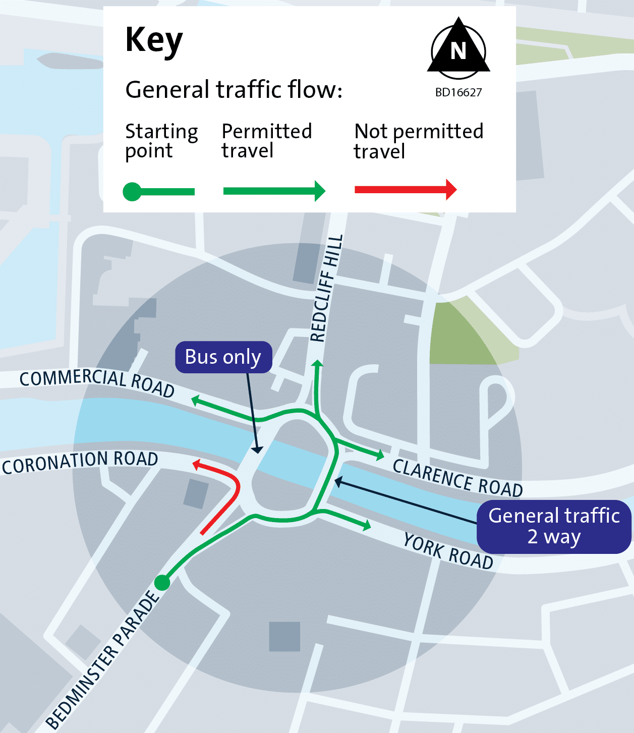
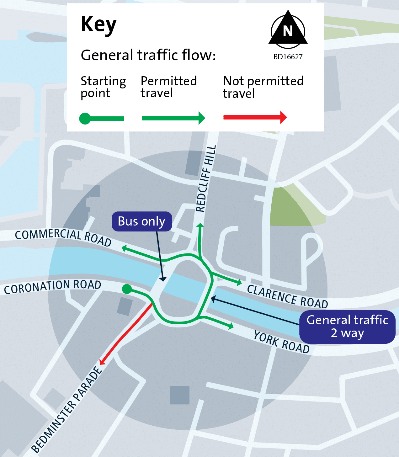
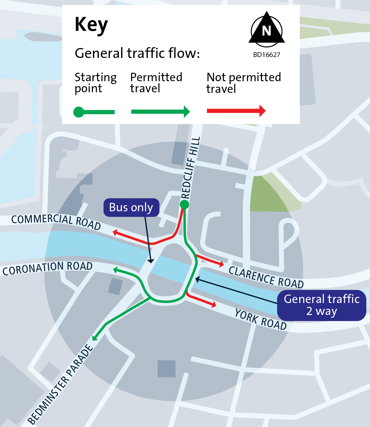
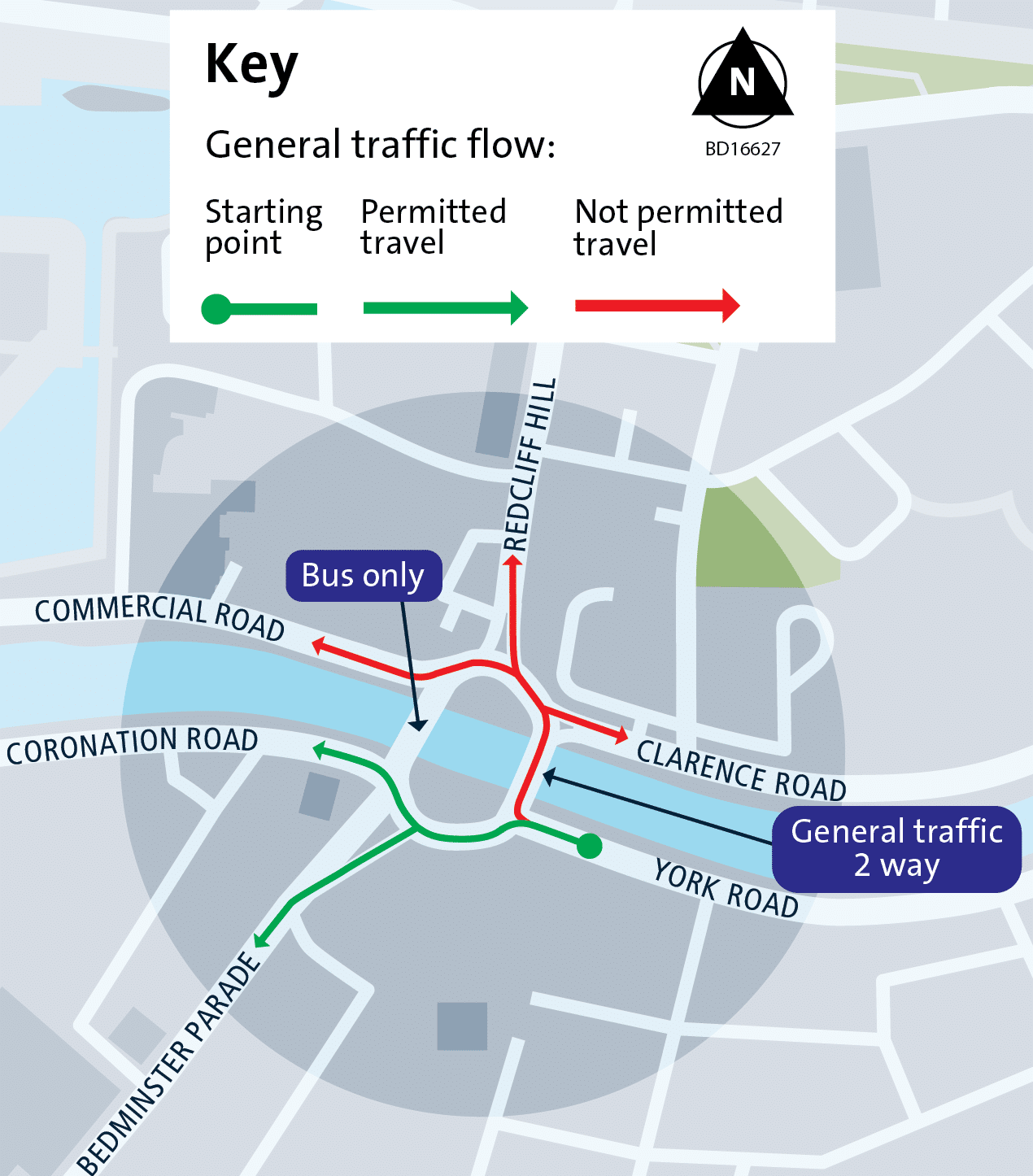
The following six graphics show which roads cars can (in green) and cannot (in red) access when approaching from the six different roads:


This image is an artist’s impression of what the junction could look like in the future, looking from the city towards Bedminster:

Looking towards the river on Bedminster Parade, these images show the proposed bus-only road through what is now a car park. The proposals have been designed to avoid the loss of the tree.


In the next two images, also looking towards the river, you can see the current bridge which is one-way. In the artist’s impression, you can see the proposed two-way bus-only road and the two-way segregated cycle route on the other side of the bus lanes.


These three images show a detailed plan of the latest design, but this could change following feedback during the summer 2024 consultation.
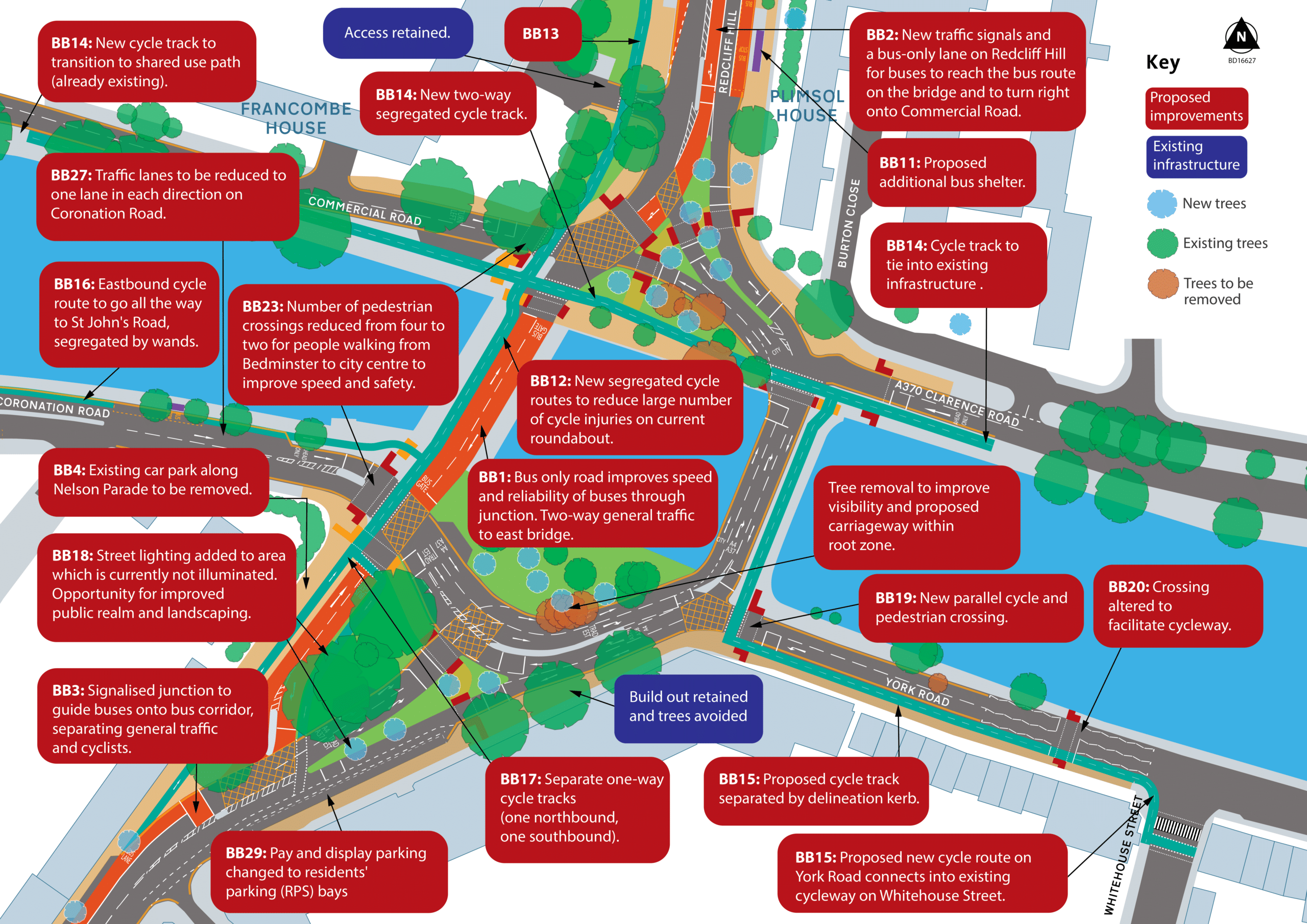
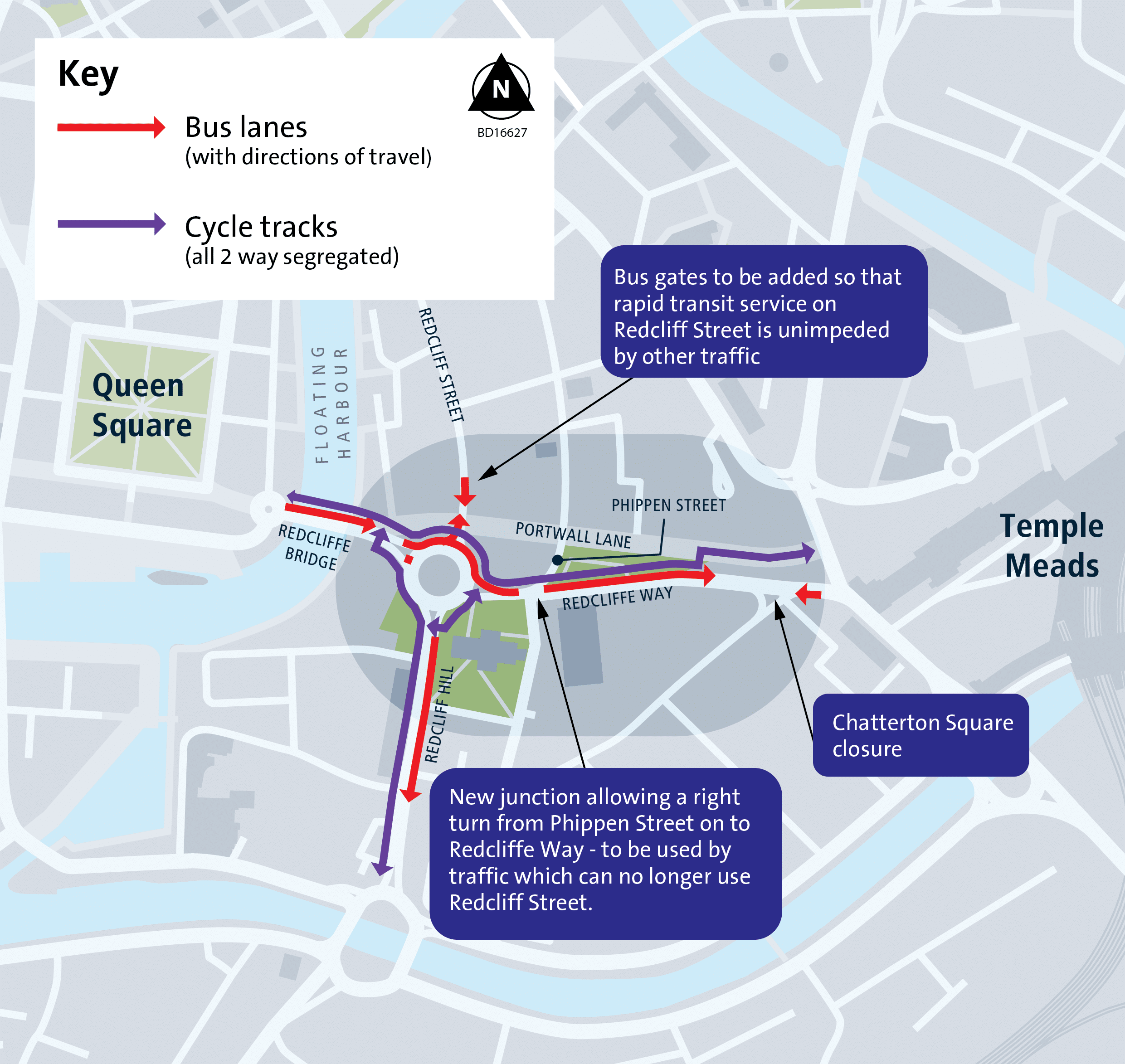
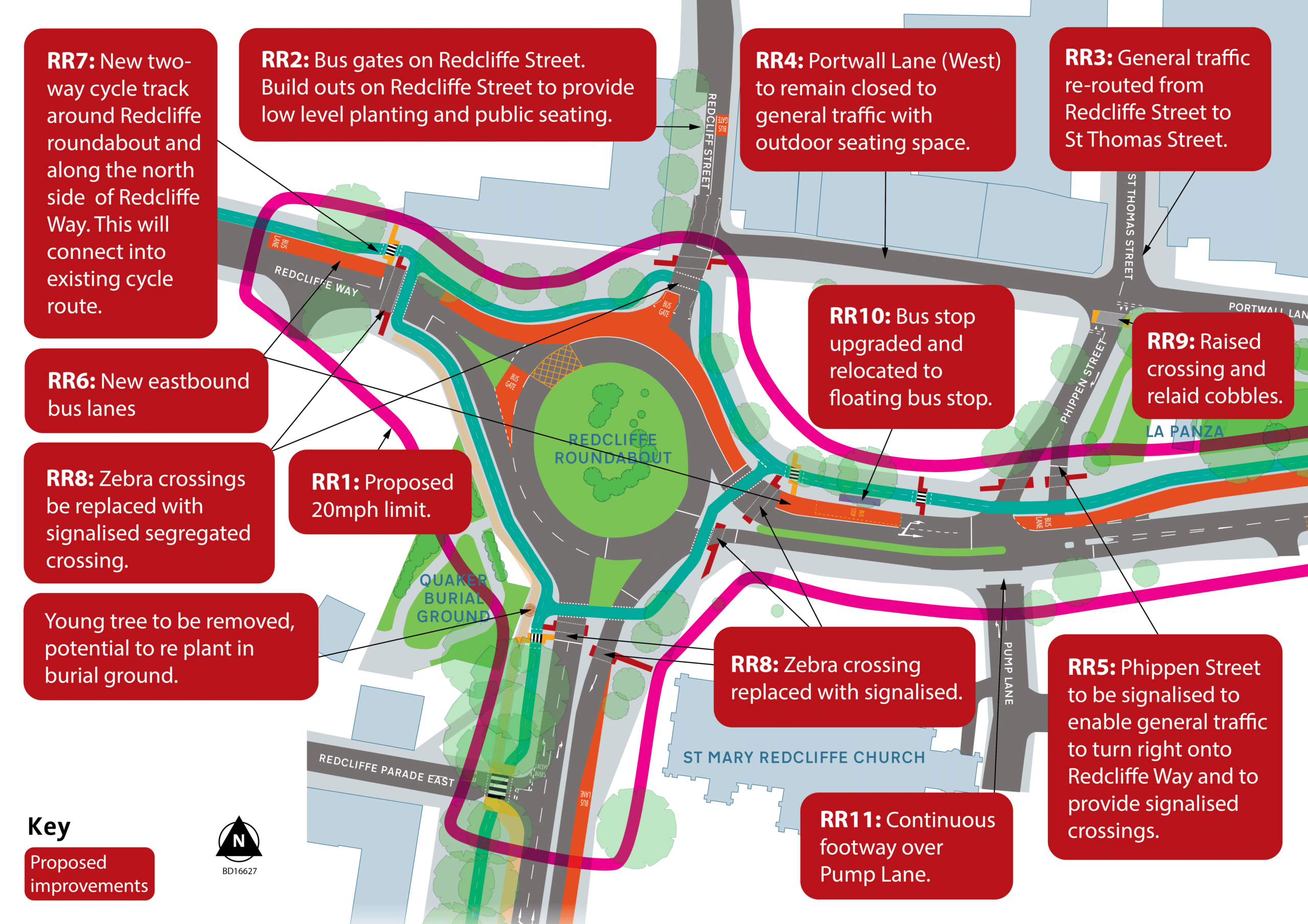
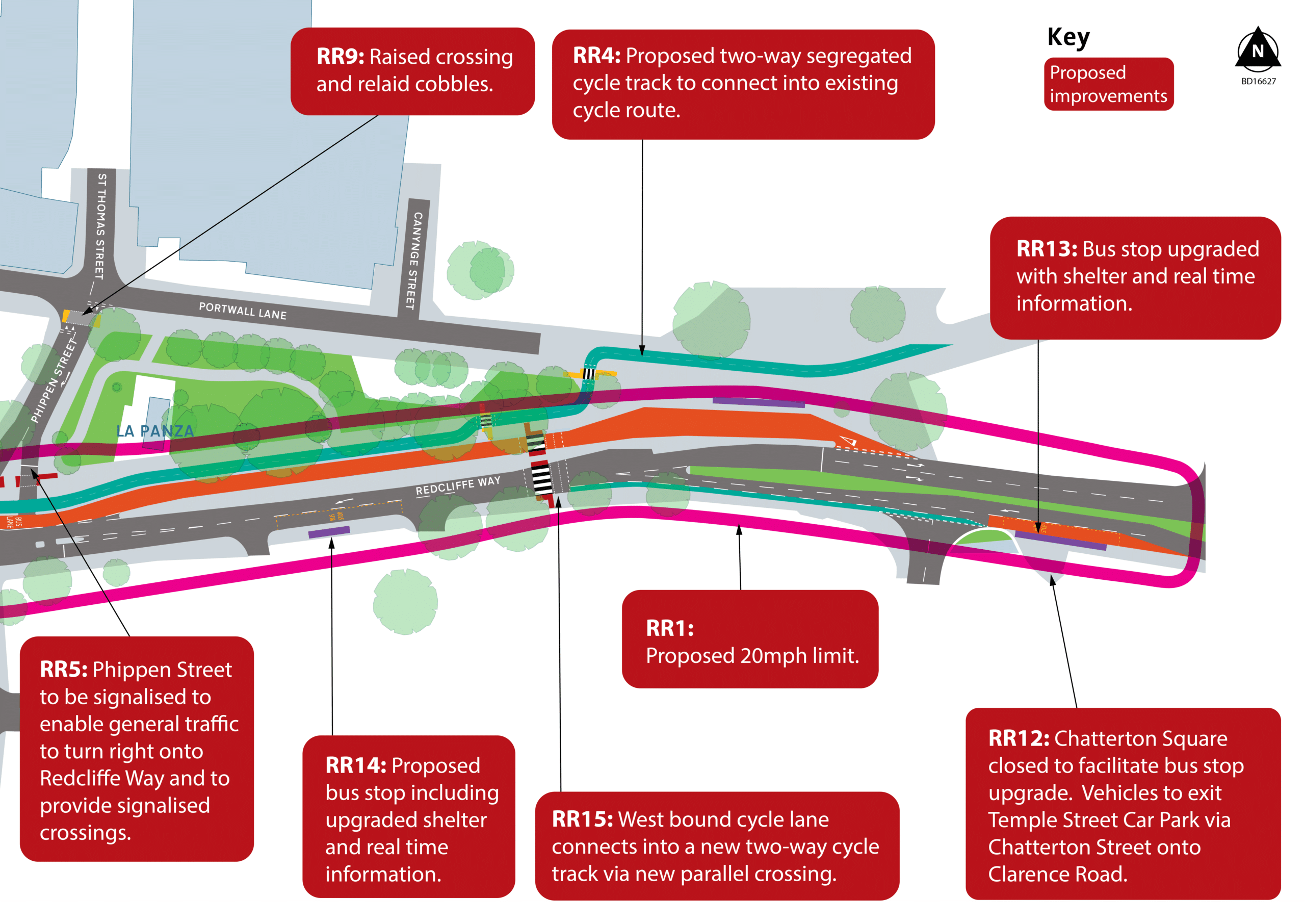
Redcliffe Roundabout
An overview of the proposals for Redcliffe roundabout, including Redcliffe Way:
- introducing bus gates in both directions on Redcliffe Street next to Portwall Lane
- realigning Phippen Street junction so general traffic can turn left and right onto Redcliffe Way – this will be used by the traffic which can no longer use Redcliffe Street.
- creating a pocket park, using space created around the bus gates on Redcliffe Street. This could include sustainable urban drainage, street trees, low-level planting and seating. Michael’s Fork in the Road food stall could be moved into this space with opportunities for customer seating
- installing traffic signals on Redcliffe Roundabout and segregated crossings for pedestrians and cyclists
- introducing a new 20mph speed limit along Redcliffe Way and around the roundabout
- closing the exit from Chatterton Square which will make more space for the bus stop and people waiting for a bus
These changes are summarised in the below image:
Here we set out more detail on the proposals, including cycle, bus priority and public realm improvements.
-
- installing a two-way cycle track on all arms of the roundabout connecting to cycle lanes at Redcliffe Bascule Bridge and Temple Circus
- providing a separate cycle track to the pedestrian walkway between the station and queens square (known as the Brunel Mile)
- introducing a two-way cycle track on Redcliff Hill that would connect with Bedminster Bridges
-
- introducing a bus lane between Redcliffe Bascule Bridge and Redcliffe Way
- installing traffic signals to sense buses to give them priority
- upgrading bus shelters with real time information electronic signs
-
- wider pavements around St Mary Redcliffe Church
- An additional crossing along Redcliffe Way to improve connectivity north/south
- treatment of side roads at Pump Lane, Phippen Street and Redcliffe Parade East to slow traffic down and to give priority to people walking, wheeling and cycling
- creating more areas for public space within new build outs, which could be used for trees, low level planting, sustainable drainage systems, e-scooter and e-bike parking
- improving the public space between Bascule Bridge and Redcliffe Street, while retaining space for The Fabulously Green Coffee Machine
-
- improving walking and cycling access to the Quakers Burial Ground and working with the community groups, who are developing proposals for a reflective space for asylum seekers and refugees, to decide how the area would connect to the Redcliffe Wharf development in a respectful way.
- co-ordinating improvements to Chatterton House Park with the Redcliffe Business Improvement District that has started developing proposals for improved public realm.
This image shows a detailed plan of the latest design, but this could change following feedback during the summer 2024 consultation:
Below are some before and after images of what the changes might look like.
Looking east on Redcliffe Way, with the train station in the background these images show a proposed new pedestrians and cycle crossing connecting offices on the north and south side of the road. You can also see the change to the road layout – currently, there are two general traffic westbound lanes but we are proposing to have one lane in each direction.


In the next two images, also looking east on Redcliffe Way, you can see the current Phippen Street junction – currently, you can only turn left into and out of this junction. In the second image, you can see the proposals which allow traffic to turn right out of Phippen Street and onto Redcliffe Way to access the roundabout. In the proposed changes traffic can still only turn left into Phippen Street.


This image shows what the proposed changes to both the roundabout and the Phippen Street junction look like in the context of the church. It is worth noting that the car park is designated as housing in the Local Plan.

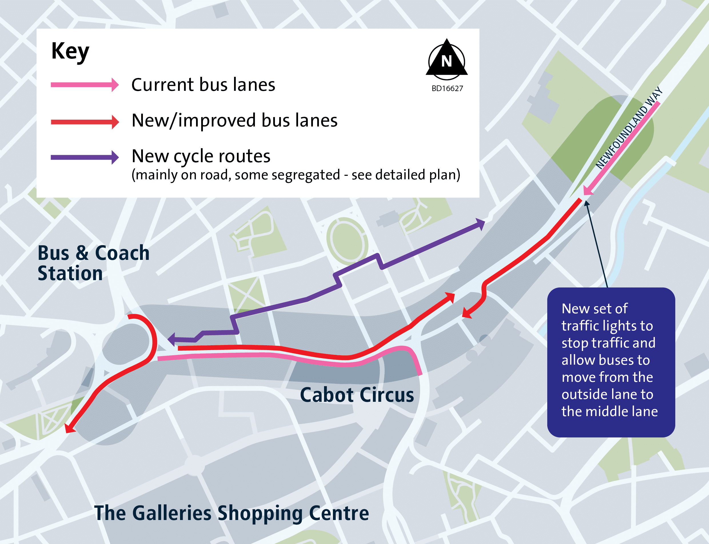
Bond Street
We are proposing a series of changes to Bond Street, including Newfoundland Circus.
The section covered includes the area from the east side of St James Barton Roundabout, Bond Street, Bond Street junction with Bond Street South, Newfoundland Circus and Newfoundland Road.
The project aims to improve the route for buses travelling between St James Barton Roundabout and the M32, as well as the route west towards the roundabout. The bus lanes would be used by three of the metrobus services, some local services, including buses to Yate, Thornbury, UWE and Newport, and many intercity coaches.
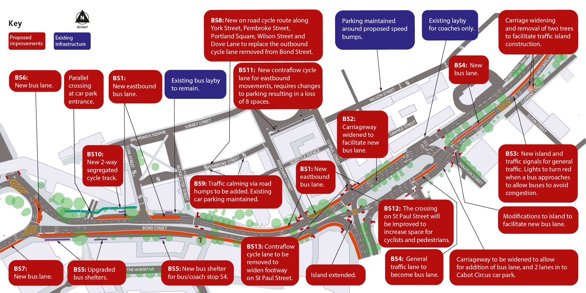
Creating an outbound bus lane on Bond Street would mean removing an on-road cycle lane and replacing it with a two-way cycle route through much quieter streets that run parallel to Bond Street. We carried out traffic surveys which told us that the level of motorised traffic on these streets is suitable for on-road cycling, in line with the latest national cycle design guidance.
Along the south side of Portland Square, the road is one-way so we are proposing a contraflow cycle lane. This would mean the loss of eight parking spaces on Portland Square and a new two-way cycle lane on the one-way street. Our parking survey found that at no point were these bays more than 42 per cent full. This cycleway would provide a safer and more pleasant route from the city centre to Concorde Way, which connects Filton and Stoke Gifford to the city centre.
Proposals include:
- installing a bus lane on Bond Street to improve the reliability of buses travelling eastbound. This requires widening the road for an extra bus lane on Bond Street
- extending the westbound inbound bus lane on Newfound Land Circus to the Cabot Circus car park entrance would mean widening the road at Houlton Street junction to install a 3m bus lane heading into Cabot Circus car park
- adding a new set of traffic signals which would stop general traffic and allow buses travelling inbound from the M32 to get from one bus lane to another easily
- creating an off-road two-way segregated cycleway from St James Barton roundabout to York Street
- creating a two-way on-road cycle route between York Street and Newfoundland Road
- installing road humps for traffic calming
- improving the pedestrian crossing on St Paul Street for pedestrians – to achieve this we are proposing removing the contraflow cycle lane
This graphic shows a high-level overview of the plans:

The next two images show a before and after of what the south side of Portland Square would look like, with the addition of the contra flow cycle lane:


This image shows a detailed plan of the latest design thinking, but this could change following feedback during the summer 2024 consultation:
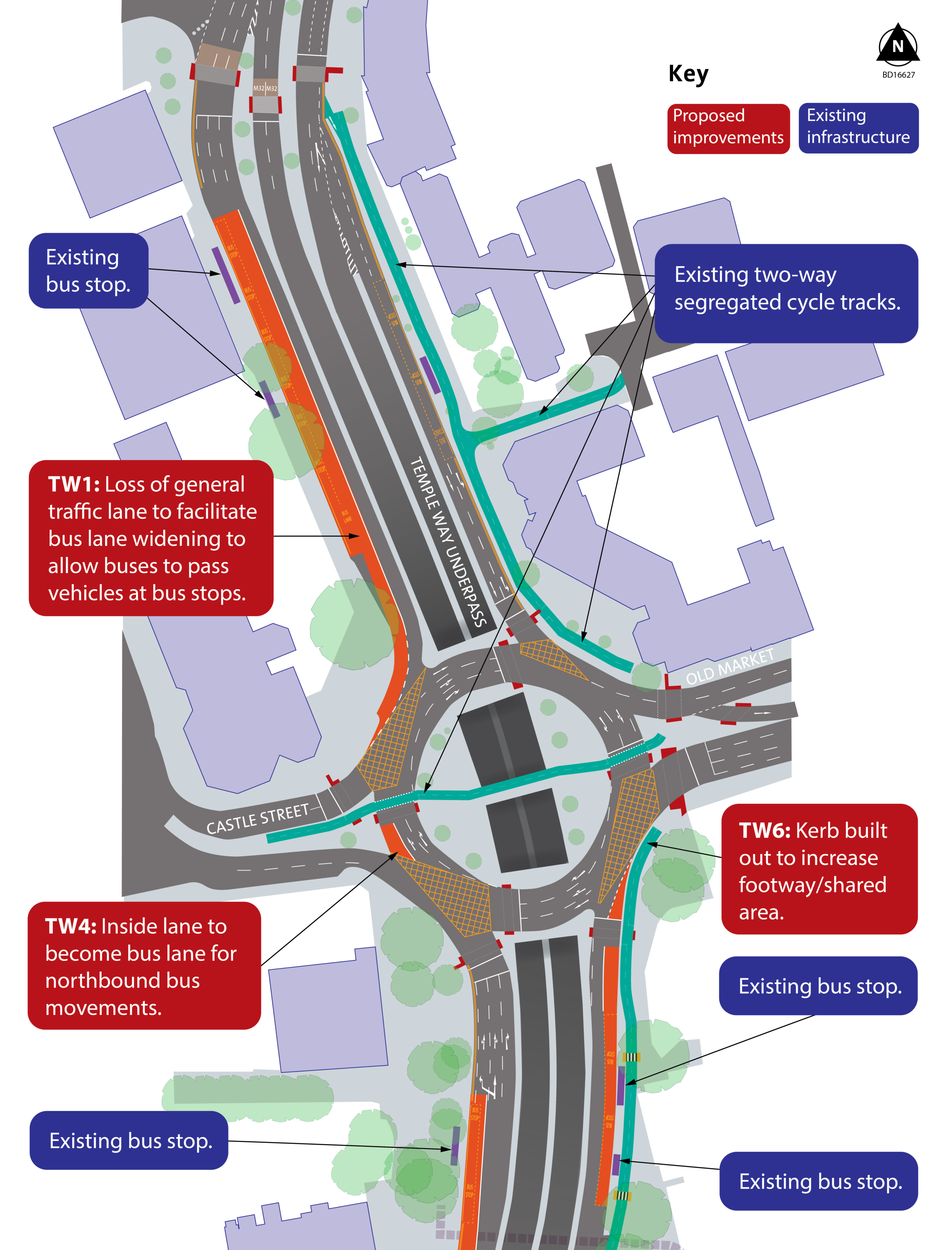
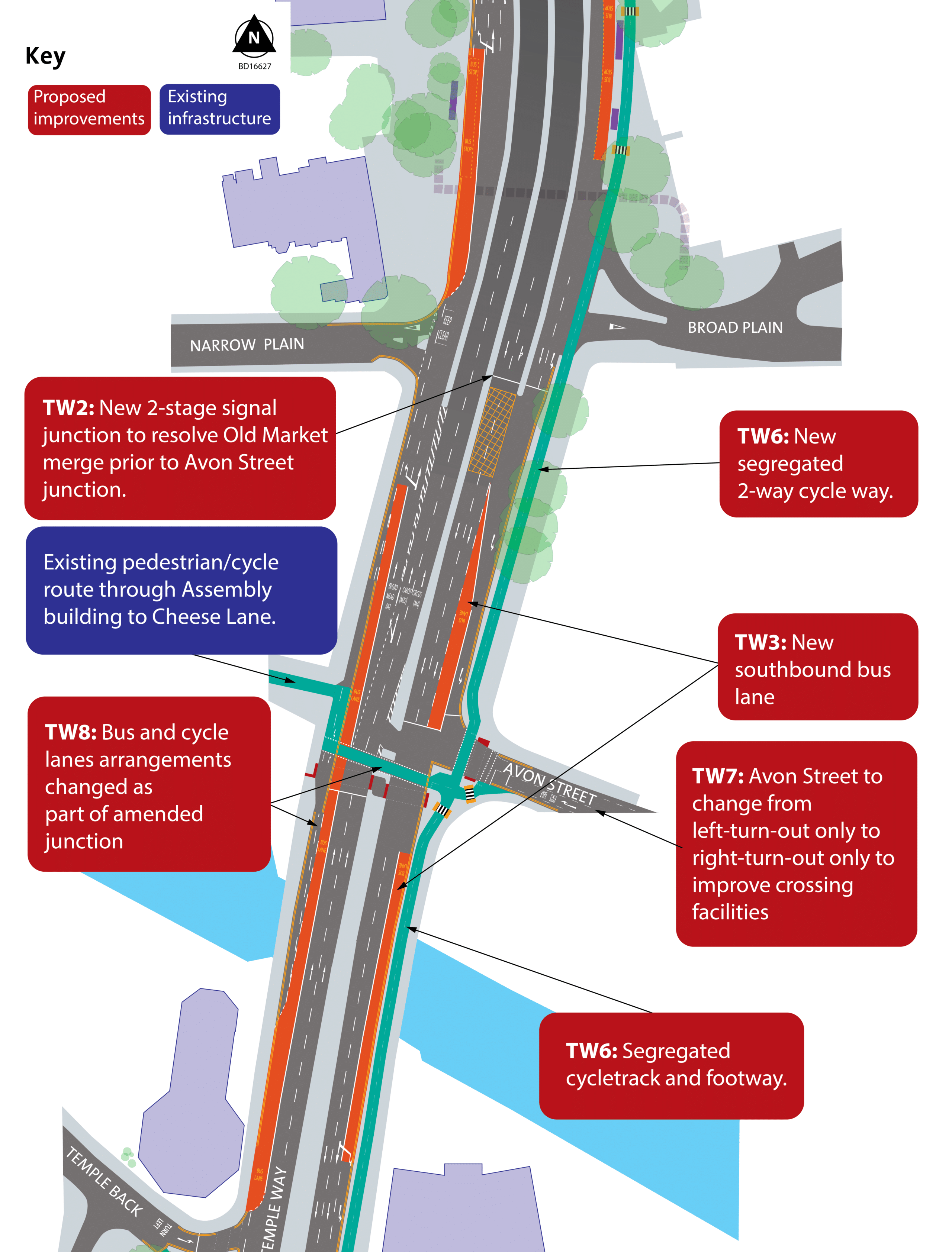
Temple Way
We are proposing a series of changes to Temple Way from its northern end to its junction with The Friary just before Bristol Temple Meads station. The proposals also include a minor change to the Old Market Roundabout and the bus stops to the north of the roundabout.
The changes would make buses travelling through along Temple Way, more reliable and improve pedestrian and cyclist safety and access.
A high-level overview of the changes is given in this graphic:
The proposals include:
- adding a new bus lane alongside the bus stops S14 and S14 – these are just to the north of Old Market Roundabout
- changing the layout of the southbound slip road from Old Market Roundabout so that we can add a two-way segregated cycle route and a bus lane which bypasses the bus stop
- relocating bus stop T8 to the south so we can add a bus lane alongside the bus stop and buses not stopping at this stop can overtake stopped buses
- installing a two-way segregated cycle lane from the corner of Old Market Roundabout by the Stag and Hounds to The Friary, outside Ovo Energy, and better cycle crossings across Temple Way at Avon Street and Temple Back to Temple Back East
- maintaining a pavement of at least 2m in width for this same length, where they are not slightly restricted by trees
- providing a small section of bus lane on Old Market Roundabout to help buses coming from Old Market and turning north
- narrowing the central reservation to the north of Temple Back East to allow for high-quality cycle crossing facilities east-west as well as north-south
- retaining the trees on the east side of Temple Way, repairing the pavement that their roots have broken, and possibly adding new planting and sustainable urban drainage
- upgrading the southbound bus stop opposite Tower Street
The below three images show the plans in more detail:
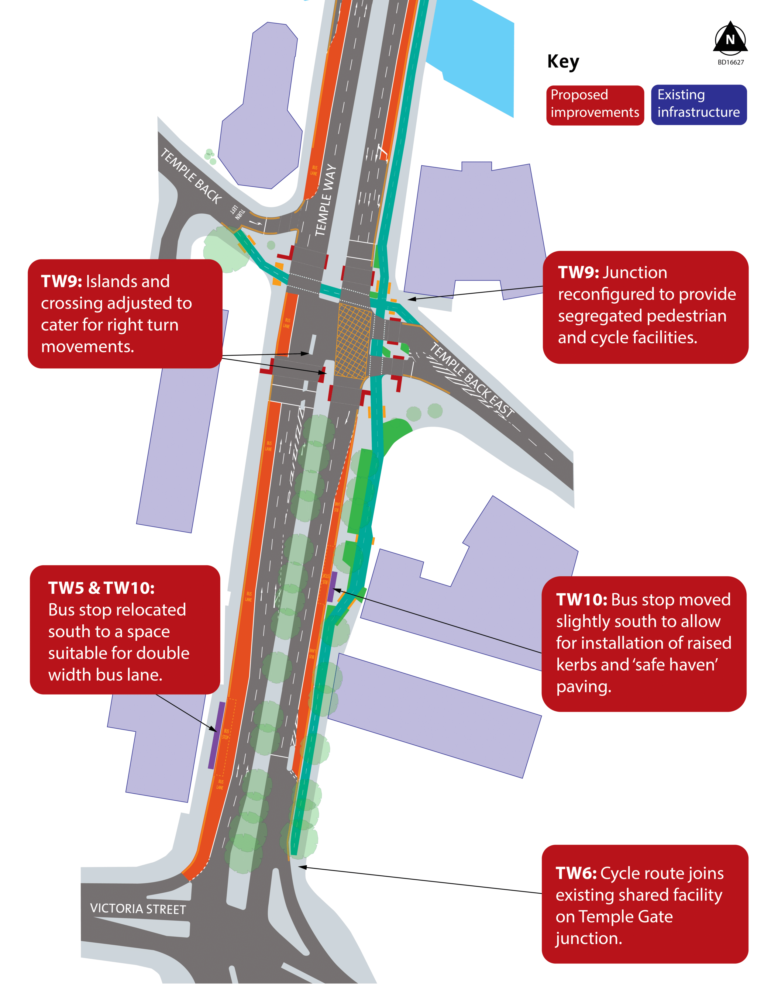
These images show the current Temple Back East junction and what it could look like after the changes:


These images show the current Broad Plain junction and what it could look like after the changes:

What happens next?
This consultation is the first step in a three-year project to transform Bristol’s city centre. Once the responses to the survey have been analysed, we will publish a report that summarises the feedback. This will inform how the plans for the project are progressing and what changes are needed. We may need to consult you about more detailed plans in future.
There are other projects – some led by Bristol City Council and some by developers – which we will ask you about in the future.


