


Worle High Street improvement works to begin later in the year following programme revisions
Work to improve Worle High Street in Weston-super-Mare is set to get underway later in the year following changes to...
Read moreTo date, Bristol City Council has successfully launched the School Streets scheme with seven primary schools in the city. This was extended to Ashley Down Primary school, which launched on the 2nd October 2023.
The main aims of Bristol School Streets are to:
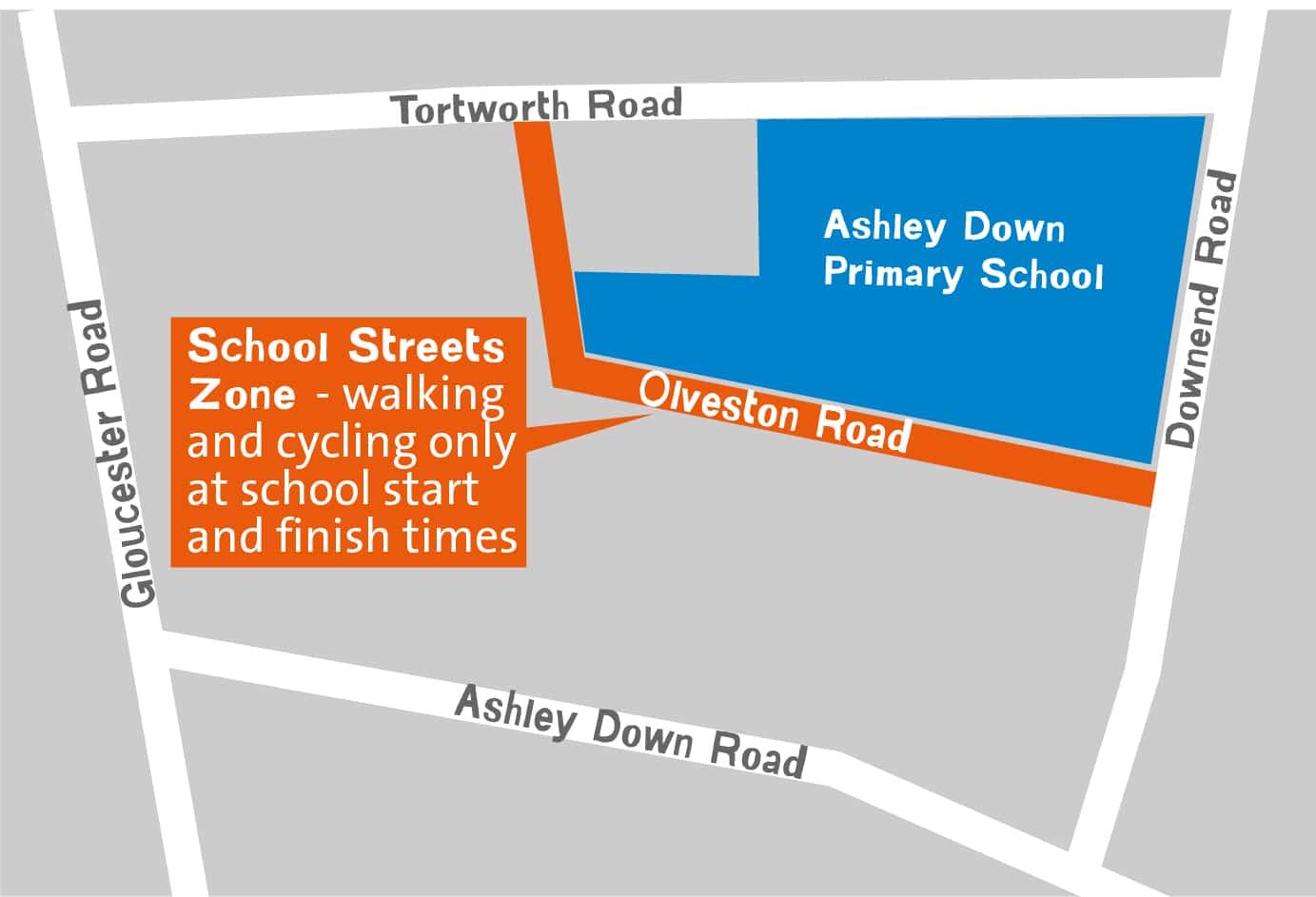
To reduce traffic danger and congestion in the area, Bristol City Council has turned Olveston Road into a walking, wheeling, cycling and scooting-only zone at school start and finish times.
Vehicles are not permitted to enter the zone for approximately 40 minutes in the morning between 8.30am and 9.10am and 40 minutes in the afternoon between 2.50pm and 3.30pm. Emergency vehicles, Blue Badge holders and Olveston Road residents are exempt from these restrictions.
The scheme is enforced by the police. The penalty for ignoring the prohibition is a fixed penalty notice. Advanced warning signs have been installed, and temporary barriers placed at the entrance to the scheme. All vehicles already parked in the zone before the times of operation are able to exit without incurring a fixed penalty notice.
School Streets makes it easier for Blue Badge holders to access the school entrances by reducing traffic outside the school gates. Those holding valid Blue Badges are exempt from the restrictions but existing parking restrictions (e.g. double yellow lines) still apply. We ask that Blue Badge holders display their Blue Badge clearly in the windscreen of their vehicle and they may be stopped and asked to confirm their details on some occasions.
We ask people with additional access requirements and those with disabilities to contact the Bristol School Streets team to discuss any personal access needs as they may be eligible for an exemption access permit.
Parents or carers dropping children at school are not eligible for an exemption, unless you or your child are a Blue Badge holder, resident of Olveston Road or have access needs. We are pleased that parents at our existing Bristol School Streets schools are embracing the scheme and are choosing to walk, cycle or scoot where possible.
School staff need to be inside the School Street zone area before it comes into operation. Only staff who have a Blue Badge are exempt. School staff are able to leave the zone during the times of operation without requiring an access permit.
Bristol School Streets encourages and prioritises a safe environment around schools to allow for walking, cycling and scooting. Parents and carers who feel they need to drive will need to park legally nearby and walk the remainder of the journey.
We are working with the school to promote active travel to school, which includes walking, wheeling, cycling and scooting.
Evidence suggests that where School Streets have been implemented, the result is a reduction in car use rather than displacement to surrounding streets. We are continuing to monitor the impact of the scheme now it has been implemented
.
Data was collected before the scheme was implemented and is being monitored now the measures are in place. The change in traffic levels, parking surveys, how pupils travel to school and feedback from the local community are all being used to measure the success of the scheme.
If you have a specific query, that has not been answered in this page, please contact us via the below email address.
Work to improve Worle High Street in Weston-super-Mare is set to get underway later in the year following changes to...
Read more
In his first visit since becoming Prime Minister, this morning Andy Burnham joined the West of England's Mayor at the...
Read more
Essential resurfacing works will be taking place along the A4 Portway throughout this summer and autumn.
Read more
Work to make it safer and better for children and families to walk between three schools in Midsomer Norton is...
Read more
Plans to improve sustainable transport links along the A4 between Bath and Bristol are continuing to move forward as construction is...
Read more