Cycle Ambition Fund: Filwood Quietway
Bristol has been awarded additional funding from the UK government to upgrade walking and cycling routes across the city. £19m has been allocated for projects from 2015 to 2018 in the Bristol area.
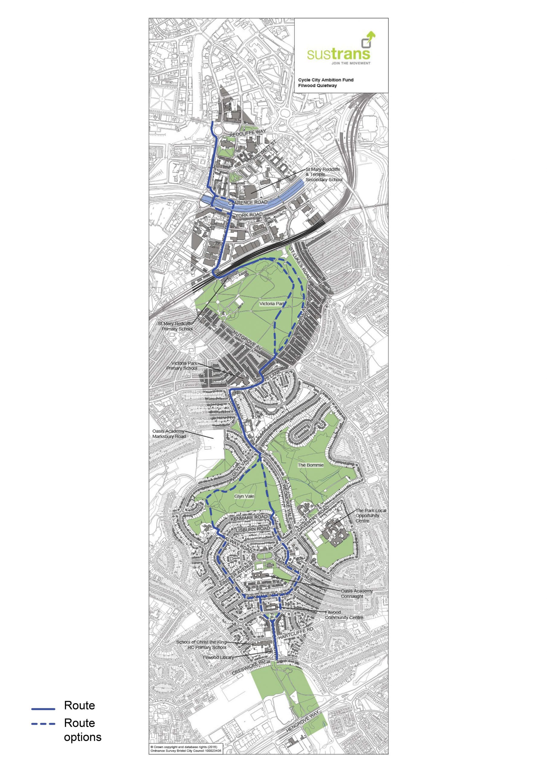
One of these routes is the Filwood Quietway. This new route will link Filwood Broadway and Hengrove to the City Centre, giving communities in South Bristol a proper, healthier alternative for transport.
Now completed
All the Cycle Ambition Fund projects are now completed in Bristol. This page serves as an archive of the work done.
Filwood Quietway Sections
Whitehouse Street
We want to make Walking and Cycling routes in Bristol as safe and enjoyable as we can. Whitehouse St will feature a new segregated cycle route, with increased planting and an upgraded footway. The segregated cycle route is an important part of these proposals.
For many people, cycling on the road feels unsafe, so the segregated route provides a dedicated space away from motor vehicles.
Hardy low-level plants will be installed by the carriageway as part of a SUDS (Sustainable Urban Drainage System), and trees will be planted where space and utilities permit.
Whitehouse Street Drawing 1 Download pdf PDF approximately 818.53 K Whitehouse Street Drawing 2 Download pdf PDF approximately 670.86 K Whitehouse Street Drawing 3 Download pdf PDF approximately 638.38 K Whitehouse Street Drawing 4 Download pdf PDF approximately 750.56 K Whitehouse Street Drawing 5 Download pdf PDF approximately 498 K Whitehouse Street Original Proposals Download pdf PDF approximately 12.25 M
Victoria Park
Our proposals for Victoria Park forms a vital part of the Filwood Quietway, linking South Bristol to the city centre, with a safe and direct route for walking and cycling.
Proposed Changes
The Council previously proposed some improvements for Victoria Park, which focused on a new walking and cycling route through the park. This was subject to a planning application, which was subsequently withdrawn in January 2017. We have listened to the concerns raised during the previous planning process, met with key local stakeholders and re-designed to address comments.
This scheme is being progressed by the Council, as part of its Cycle Ambition Fund (CAF) project, which is mainly funded by a successful bid to the Department of Transport. The CAF project is a range of schemes and initiatives that seek to encourage people of all ages and ability to cycle more to reduce traffic congestion, improve the health of citizens, and reduce carbon emissions for a cleaner environment for all.
Victoria Park is part of the Filwood Quietway route we are progressing, which has a number of sections – Whitehouse Street, Victoria Park, St John’s Lane/Wedmore Vale and Northern Slopes.
Change of Route
The previous route went from the access at the top of Windmill Close, in the north part of the Park, running eastwards before heading south close to the east edge of the Park, by Hill Avenue, to the Nutgrove Avenue/Hill Avenue access. There were objections about the route running close to Hill Avenue and also about the new sections of path.
Following discussions, the route has been changed and is now more central. This is a shorter route for those pedestrians and cyclists wanting to travel along the Filwood Quietway. The majority of the route uses existing paths, which would be widened. At the south end, a short section of new path is proposed to reduce impact on existing tree roots and the old path would be removed.
Change of Width
The previous path, being approximately 850m long, was to be between 4.3 – 4.7m wide, depending on location. It would have been segregated, with cyclists using one side and pedestrians using the other. However, there were lots of objections, mainly about the path being too wide but also with segregation. Many people felt a wide, segregated path would encourage cyclists to travel at speed.
The new path is now proposed to be 3.0m wide and approximately 760m long. We found that parts of the existing route are wider than we all thought, because of overgrown grass on its edges. In some places, the existing path is almost 3.0m wide if the grass was cut back and tarmac levels reinstated.
Impact on Trees and Planting
The original route required the removal of three trees and relocating a small one. Six new trees would have been planted to compensate for the loss of these trees. The previous route also required the installation of a short section of ‘no dig’ cellular confinement system for path construction adjacent to a mature tree, to protect its roots. The original route also included the removal of a strip of the self-seeded bushes and woodland scrub along the northern boundary for the construction of the widened path.
The new route does not require the removal or relocation of any trees. However, the route does run close to more trees and, therefore, longer sections of the ‘no dig’ cellular confinement system path construction are required. The new route will have minimal impact on other plantings. Planting along the northern boundary will no longer be affected, other than for minor pruning of any overhanging branches. Ground vegetation and grass that has overgrown across the edges of affected paths will be removed.
Lighting
Whilst lighting the new path is not mandatory, it is desirable to light it so that users feel safer and more secure during hours of darkness. Lighting proved to be a contentious issue during the previous consultation, with responses split on whether it should be provided or not. It was also a common comment in responses to the planning application.
We will be using intelligent LED lighting heads and operating hours for the lighting will be 05:30 – 19:00 at full brightness; 19:00 – 22:00 at 30% brightness; and 22:00 – 05:30 lights switched off. At this time, we are only providing 6 new columns and lanterns on the north section of the route.
- The system operates at standard brightness until the suggested time of 7:00 pm, when there are fewer people likely to be using the route
- After 7:00 pm, the lights can be set to dim down to 30% brightness or less
- For special events (e.g. bonfire night/fireworks), the lighting can be remotely controlled to fully deactivate, as and when wanted
We also considered using shorter columns but we would have needed more of them, which would have resulted in closer spacing and increased power consumption.
Impact on wildlife and Dark Sky Status
Whilst there is some existing lighting already within the park, many of the existing paths are not lit. It is appreciated, therefore, that there are concerns with regard to the impact on wildlife and also the Dark Sky status of the park. It is proposed, therefore, to use warm LED lighting that will be directed at the path only. The proposed heads we have chosen will obscure the light source from above and behind in order to keep the light spill to a minimum. Additionally, the column height will be approximately 4.7m (similar to existing lighting columns within the park) and spaced at approximately 30.0m to reduce the number needed. With the dimmed lighting activated and ability to switch the lights off during the middle of the night, this will reduce the impact on nocturnal wildlife, especially bats, using the park and also the Dark Sky status.
Bats hibernate during the winter months when the lights would be most in use. A survey along the proposed route found no evidence of any bat roosts in any adjacent tree. In addition, lighting will be downwards rather than onto the trees.
The minor widening now proposed and the ‘no dig’ construction should have minimal impact on existing wildlife.
Historical Entrances Restoration
As for the previous scheme, it is proposed to reconstruct the gate piers at the Nutgrove Avenue/Hill Avenue entrance and also reconstruct the missing gate pier at the top Windmill Close entrance. The restoration work to the two of the existing entrances will match the original designs that still exist in other locations, for example at Somerset Terrace.
For the Nutgrove Avenue/Hill Avenue entrance, we have also been requested to widen the entrance slightly, by approximately 0.5m, in order to allow larger vehicles to access the park more safely. This will be helpful for certain park events.
Entrance Barriers
Victoria Park has 14 access points around its boundary. The majority of these can be used by users of standard size wheelchairs and bicycles. In order to improve access for all users, including larger wheelchairs, motorised buggies and non-standard bicycles, the previous scheme had proposed to replace existing barriers at three locations with bollards. There are instances of anti-social behaviour, in terms of motorbikes/mopeds gaining access the park. This would have initially been on a trial basis, for up to 12 months, as agreed with the Police, to assess if there was any increase in anti-social behaviour.
Barriers were another area of concern during the previous consultation and in responses to the planning application. We have considered this matter further and will not undertake these changes, as part of the revised design. We have discussed this issue with VPAG/Forward Together representatives and agreed on the following changes:-
- 7 existing A-frame cycle barriers will be replaced by new K-frame cycle barriers. Initially, the K-frame pads will not be fitted meaning easier access for disabled users as well as cyclists
- the existing Hill Avenue/St Luke’s Road access will be altered, in order to have the barriers set back into the park, in order to provide a safer waiting area on the external side
St John’s Lane and Wedmore Vale
Our proposals for St John’s Lane and Wedmore Vale will make it easier and safer to walk and cycle from the city centre towards Knowle and Filwood.
Consultation booklet with initial proposals February 2017 Download pdf PDF approximately 3.39 M Updated drawing post consultation results – March 2019 Download pdf PDF approximately 843.67 KNorthern Slopes
For the Northern Slopes section, we have prepared a scheme design and discussed it with a number of stakeholders, including the Northern Slopes Initiative (NSI).
On 8 November 2017, planning consent was granted for the Northern Slopes cycle route scheme, subject to a number of conditions.
Route and Design
On the eastern side of the Glyn Vale Open Space, an existing path runs north from Kenmare Road to an access point by the Glyn Vale/Wedmore Vale junction. This path is only 2.0m wide and much of it is enclosed by trees and scrubland. There is no existing lighting, so it can be dark and some users may not feel safe.
We propose to build a route that would widen parts of the existing path and have sections of new path. After discussions with stakeholders, it has been agreed the new path would be 3.0m wide. Those parts of the existing path that are not changed will remain as an alternative route for walkers only. In the future, it may be desirable to remove these existing path sections and replant them.
The majority of stakeholders want the new path to be shared by pedestrians and cyclists. A shared path may help to encourage cyclists to travel more slowly. To encourage cyclists to give due consideration to pedestrians, we intend to have rumble strip effect surfacing and some advisory signage at junctions with other paths and on approaches to access points. The new path will be constructed with blacktop bituminous material but we are considering surfacing the new path with buff-coloured anti-skid surfacing, like the existing path, to make it less slippery.
When leaving the Open Space area and heading north, the Filwood Quietway would continue along the proposed St John’s Lane/Wedmore Vale cycle route we are also developing and consulted upon earlier in the year. If heading south, we intend to sign a recommended route, initially using some of the quiet roads, such as Newry Walk and Connaught Road. Further south, new sections of the Filwood Quietway can only be delivered when the Council gets further funding or as part of development proposals, such as at Filwood Broadway.
Impact on Trees and Planting
Although the existing path is almost straight, much of it is very steep and going up the hill can be quite difficult and be tiring from some users. Coming downhill, some cyclists may go fast, which can be potentially unsafe for them and other people, as the existing path is quite narrow.
The new bendy route will make the path less steep. Building this path will require a lot of earthworks, making the path higher in places (fill) and lower in others (cut) by up to 1.0m. The full width of these earthworks will be up to 15.0m wide and this will require some existing trees and the planting to be removed. Trying to do the same to the existing path would have needed earthworks up to 20.0m wide, resulting in the loss of lots more trees and planting, including some mature trees.
We have undertaken an ecology study and a tree survey and, whilst there will be some loss, the new route is designed so we are avoiding bigger trees and the more sensitive planting areas. The tree survey makes recommendations with regard to removing some poor value trees and also preparing a tree protection plan for the works.
Construction of the new path does give the opportunity to undertake some tree/scrubland maintenance, create new grassland habitats and plant new vegetation.
Lighting
Whilst lighting the new path is not mandatory, it is desirable to light it so that users feel safer and more secure during hours of darkness.
We will be using intelligent LED lighting heads and operating hours for the lighting will be 05:30 – 19:00 at full brightness; 19:00 – 22:00 at 30% brightness; and 22:00 – 05:30 lights switched off. At this time, we are only providing 6 new columns and lanterns on the north section of the route.
- The system operates at standard brightness until the suggested time of 7:00 pm, when there are fewer people likely to be using the route;
- After 7:00 pm, the lights can be set to dim down to 30% brightness or less;
- For special events, the lighting can be remotely controlled to fully deactivate, as and when wanted
It is appreciated that there are concerns with regard to the impact on wildlife, particularly bats. It is proposed, therefore, to use warm LED lighting that will be directed at the path only. The proposed heads we have chosen will obscure the light source from above and behind in order to keep the light spill to a minimum. Additionally, the column height will be approximately 4.7m and spaced at approximately 30.0m to reduce the number needed. With the dimmed lighting activated and ability to switch the lights off during the middle of the night, this will reduce the impact on nocturnal wildlife, especially bats.
Bats hibernate during the winter months when the lights would be most in use. A survey along the proposed route found no evidence of any bat roosts in any adjacent tree. In addition, lighting will be downwards rather than onto the trees.
We did consider alternative lighting solutions, such as solar-powered studs and bollards, but their lighting output is much lower and does not comply with British Standards for path lighting, which are the recommended standards we use for public paths. If we had decided to use such lighting, we would have had to install lots more, at 5.0m spacing approximately. This would have created a runway effect for the studs and barrier-type effect for the bollards, and would have had a significant negative visual impact.
We also considered using shorter columns but we would have needed more of them, requiring closer spacing and increased power consumption.
Entrance Barriers
Glyn Vale Open Space has a number of access points around its boundary. The majority of these can be used by users of standard size wheelchairs, whilst most cyclists have to dismount to negotiate the access barriers. The Open Space does suffer from instances of anti-social behaviour, such as fly-tipping, motorbikes/mopeds gaining access the park, and feedback from some of the stakeholders did not support making access significantly easier, in case this results in increased levels of anti-social behaviour.
The new path connects to two access points. The south access is located at Kenmare Road and has two sets of ‘kissing’ gates. The north access is located at Wedmore Vale and has a vehicular gate and a kissing gate arrangement. We have considered this matter with stakeholders, as part of the design development process and agreed on the following minor changes:
- Alter the second kissing gate at the south access, being further away from Kenmare Road, to move it so a K-frame barrier can installed
- Alter the north access barrier arrangement by moving barriers into the Open Space area and installing a new K-frame barrier
These minor improvements will help cyclists to enter and exit slightly quicker and without conflicting with users of two of the kissing gates.
Ecology
The ecology survey notes the combination of different habitats, the value of the site as part of a wildlife corridor, and the important role the site plays in allowing people to enjoy contact with wildlife. When considered in its entirety, the open space is considered to have nature conservation value in a city-wide context. This is reflected in its designation as a Site of Nature Conservation Interest (SNCI). It is also designated as a Local Nature Reserve.
The ecology report states the best means of mitigation would be to avoid the areas identified as being of greatest nature conservation value and the new route seeks to do this. The report suggests there would be a benefit in measures that include some scrub clearance in order to extend existing grassland areas, especially clearance at a particular central area adjacent to the existing path, would be valuable. The reports also state that where areas of wooded habitat are affected then the best means of achieving mitigation would be through management to diversify the structure of other wooded areas.
An initial bat survey was undertaken during 2016 and whilst bats were recorded, the level of activity was relatively minimal for the green space location. Additional surveys were undertaken in 2017 and suggest no trees with possible bat roosts would be affected.
Construction does mean there will be some initial impact and effect on wildlife and vegetation but it is considered that once new planting starts to grow and establish itself, this impact will be reduced over time. It should be noted the Glyn Vale Open Space is a large area and we are changing a relatively small part of it.
Other Potential Improvements
The key objective of the new cycle route is to provide a section of the Filwood Quietway and this would encourage users to walk and cycle through Glyn Vale Open Space rather than use on-road alternative routes. However, the creation of the new path does give an opportunity to encourage users to also consider Glyn Vale Open Space as a destination, in its own right.
To help enhance the attractiveness of the location, additional improvements could be implemented, subject to agreement with stakeholders, especially the local community. Such measures could include:-
- Provision of seating and tables, probably best using natural materials, such as tree trunks and boulders
- Information boards/signage, which helps share information about the Open Space, its history/development, flora and fauna, etc
- Woodland and plant maintenance
- Additional planting
- Informal picnic area, near Wedmore Vale/Glyn Vale entrance
- Bird and bat boxes
The new path and additional improvements offer an opportunity for some investment in the Glyn Vale Open Space. This can help enhance the existing benefits of the Local Nature Reserve and encourage more people to visit it.