

Bristol streets – Transport Corridor Improvements
To build a more inclusive and connected city, Bristol must tackle the challenges surrounding travel. With high levels of traffic...
Read moreShare: Projects
To build a more inclusive and connected city, Bristol must tackle the challenges surrounding travel. With high levels of traffic...
Read more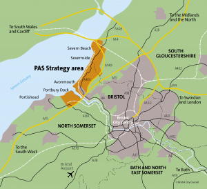
Local Authorities in the West of England are working in partnership with SevernNet to develop a joint Transport Strategy for...
Read moreWorks will take place to enable a new school to be built in Lockleaze.
Read more
The bus strategy considers options to improve the bus network and set out how further growth in bus usage can...
Read more
The Local Cycling and Walking Infrastructure Plan is a detailed plan that identifies that over £400m of investment is needed...
Read moreSt Peter’s Church of England Primary School in Bishopston was one of the council’s first pilot schools launched as part...
Read more