


North Somerset Council seeks views on improvements to the Golden Valley Bridleway in Nailsea
North Somerset Council is proposing plans to upgrade a well-used section of the Golden Valley Bridleway in Nailsea, part of...
Key aims of the PAS Transport Strategy are:
The Transport Strategy will cover the areas around and including; Royal Portbury Dock, Avonmouth village and Docks and up to Severn Beach and Western Approach at Severnside. These areas intersect three Local Authority boundaries, Bristol City Council, North Somerset and South Gloucestershire.
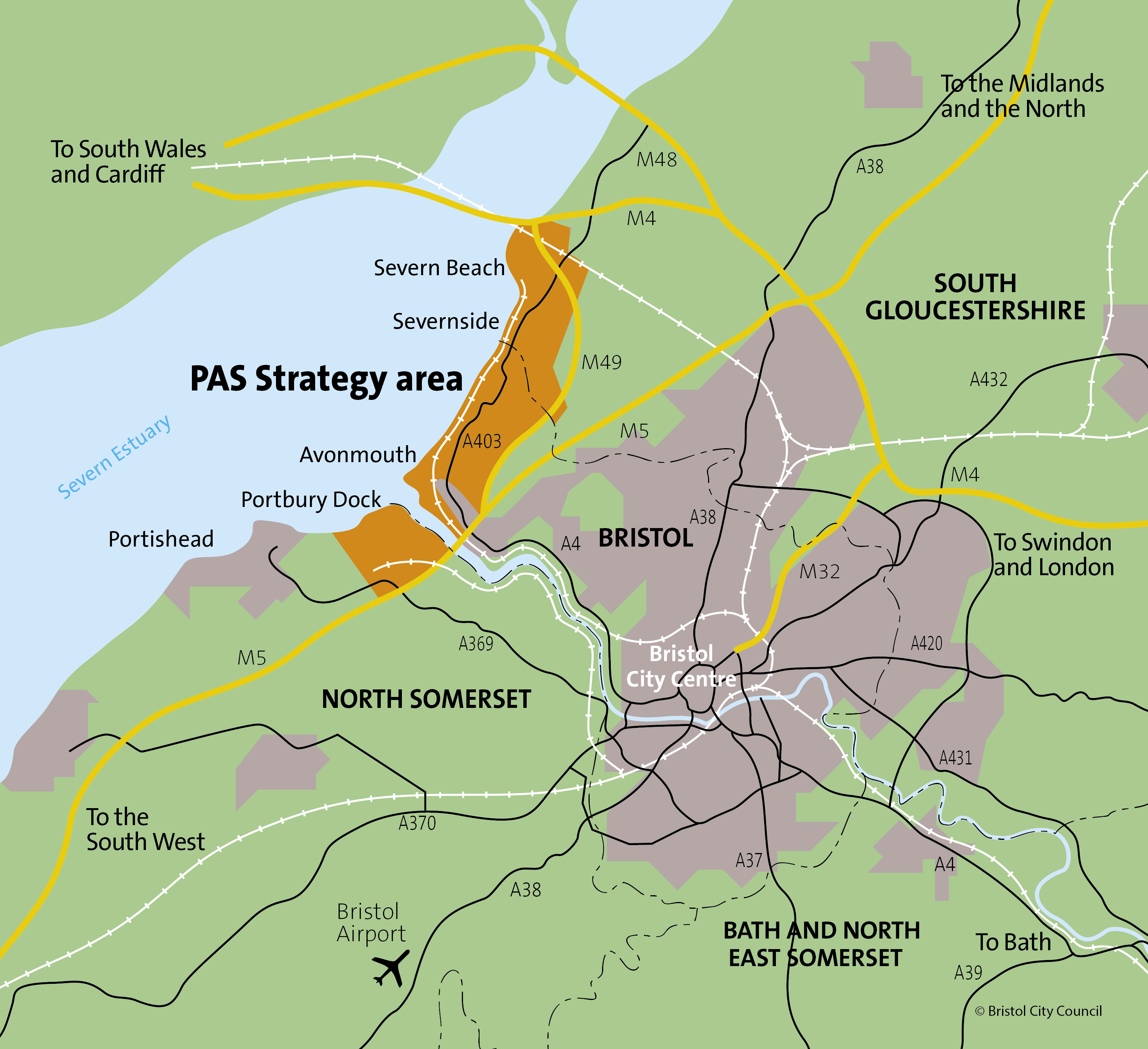
The Portbury, Avonmouth and Severnside area is one of the most important logistics locations in the West of England, though it has poor accessibility to other areas, which impacts on the ability of businesses to recruit staff and people to take up the jobs.
Those employed in the area are often only able to access employment by car, as a result the limited public transport options currently available. Given the planned growth in the area, this will become a progressively more important issue, with traffic levels across the region projected to rise.
We are currently undertaking a transport study of the area. Once complete, this evidence will inform the basis of the Transport Strategy.
The study will identify the challenges and opportunities regarding transport provision within the PAS area, and will take the format of a recommendations report.
Data will be collected on existing travel options to and around the area; the type of jobs and shift patterns; the areas workforce home locations; barriers to accessing the area, with an emphasis on barriers from areas of deprivation; and the impacts of the removal of the Severn tolls on both workforce home locations and movements to the area.
We will be holding a number of events across the region in early 2020 and we want to hear your views on how the current transport options linking your area to Portbury, Avonmouth and Severnside act as a barrier to employment.
Find out when the nearest upcoming event is taking place in your area:
Engagement events will resume when it is safe to do so, and in line with UK Government guidelines on Covid-19.
You can also complete our online survey and have the opportunity to be entered into a prize draw to win £100 Love2Shop vouchers here: travelwest.info/pas/survey
The Strategy is being produced for the West of England, by Officers from Bristol City Council, North Somerset and South Gloucestershire, who are working in partnership with SevernNet, a not for profit company operating in the Portbury, Avonmouth and Severnside area.
Over the last 10 years SevernNet have built links between businesses, the community and other stakeholders, and work with over 200 businesses and organisations.
We undertake engagement with stakeholders and the wider public to inform the direction of any Strategy document we produce. This takes place before we have any concrete idea of the shape the work will take, with the idea being that your views and comments help us to go in the right direction.
We will use responses from this initial engagement to inform the draft strategy. Once drafted, we will go out to public consultation.
We will then make further changes based on the feedback from the consultation, and will take the amended Strategy to our elected leaders to be singed off as Policy. At this stage the Strategy becomes a statutory document, which any transport plans for the future must be aligned with in principle.
A transport strategy is a policy document that sets out how a single local or combined authority aims to improve transport in a specific or wider region within their jurisdiction.
A Strategy is typically a high-level set of principles which provides the framework for future, more detailed plans to come forward for implementation.
The West of England Combined Authority has made a commitment in the recently published Joint Local Transport Plan 4 (JLTP4) to develop a joint strategy for movement for the area.
The Portbury, Avonmouth & Severnside Transport Strategy will align with the principles of the JLTP4, in balancing the requirement for distributing goods, with mitigating the adverse impact of vehicles and promoting sustainable modes of transport as the most attractive way to travel within the region.
Together the areas of Avonmouth and Severnside make up the Avonmouth & Severnside Enterprise Area (ASEA). Enterprise Areas are designated for businesses to locate to, encouraged by a range of incentives, such as tax breaks or business rates discounts.
Given the planned growth in the ASEA, it is vital we provide a range of transport options to ensure people can access jobs without reliance on private vehicles and congestion can be mitigated to help keep freight and services moving on our local and strategic transport networks.
The Royal Portbury Dock faces similar issues to the ASEA, with 24 hour shift patterns and suffers from poor connectivity to potential areas of employment within the region.
One of the aims of the Transport Strategy is to improve transport connections between areas of underemployment across the region to job opportunities in Portbury, Avonmouth & Severnside.
Historically, it has been challenging for people living in these communities to access the Portbury, Avonmouth & Severnside area. We aim to improve connectivity for these people in order to for them to access employment and education opportunities.
Yes! The responses we receive from the early engagement we are undertaking in early 2020 will inform the basis for the draft Strategy. Once produced, this will go out for public consultation, with feedback informing any changes we make.
The partnership approach we are taking with SevernNet means that businesses across the area are represented and can input during the process of producing the Strategy. The aim is to ensure we produce a Strategy that reflects the needs of both employers in the area, as well as those who currently face barriers in accessing employment because of a lack of transport options.
We are underway with the Transport Study, and the data from this will feed into the Transport Strategy development, running alongside it until the Transport Study is completed in May 2020.
When issues and opportunities have been identified we will begin to identifying measures; Summer 2020, when we will produce the draft Strategy for engagement and consultation; and Summer 2021, when we are looking at the Strategy being adopted.
The Transport Study is designed to inform the basis of the Transport Strategy, and will;
If you’d like to raise something else with us please use the contact below.
IMPORTANT: To provide your opinion on the strategy please attend one of the events (identified above) or answer our online survey. Views sent via this contact form will not be added to the engagement responses.
North Somerset Council is proposing plans to upgrade a well-used section of the Golden Valley Bridleway in Nailsea, part of...
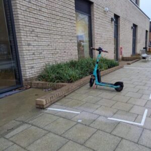
Bristol City Council has created 44 dedicated parking bays for shared e‑scooters and e‑bikes over the past nine months, helping...

A cycling hub for Bristol and the West of England region is one step closer to becoming a reality after...

A consultation is now open asking residents for their feedback on proposals for safer 20 miles per hour (mph) limits on around...

A new plan that sets out how Bristol will significantly expand its network of electric vehicle (EV) charge points over...