
Cycle Ambition Fund: Malago Greenway
Bristol has been awarded additional funding from the UK government to upgrade walking and cycling routes across the city. £19m has been allocated for projects from 2015 to 2018 in the Bristol area.
One of these routes is the Malago Greenway. We are working to make this route a quiet, safe and enjoyable route to get people to work or play all year round. Improving facilities for pedestrians and cyclists along the Malago Greenway will help give communities in South Bristol a better, healthier alternative for transport.
Now completed
All the Cycle Ambition Fund projects are now completed in Bristol. The below page serves as an archive of the work done.
Help us create a safer and more attractive Malago Greenway
In early 2016, we collected your thoughts on how we could get you, and others, using this route regularly or more often.
To spark a discussion between local communities and other users, we created an interactive map online where everyone could add their comments and see others’ opinions on the part of the route between Whitehouse Lane and Hartcliffe Way.
Speaking to users of the existing path at three locations allowed us to get a picture of existing issues. Using an interactive on-line map, people were able to comment on any aspect of the existing route. This engagement gave us an understanding of aspirations for improvements.
Common issues were raised and the top 6 key issues were:
- Unsafe (existing fear of crime)
- Barriers
- Lighting
- Crossings
- Cycle path needed
- Dangerous (existing road safety)
The feedback collected helped us progress with the project, and we have produced a number of scheme designs at various locations along the route.
Malago Greenway map Download jpg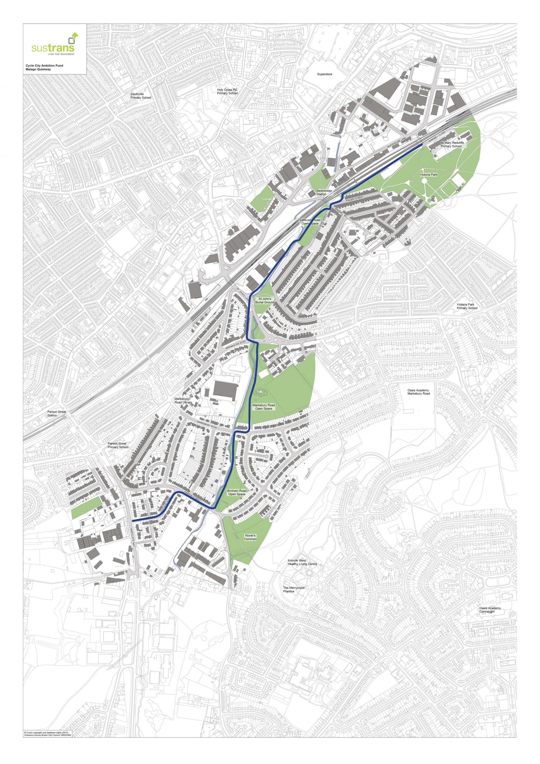
Malago Greenway Sections
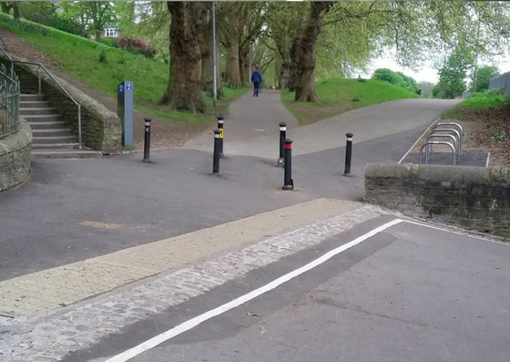
Windmill Close / Victoria Park
Works to improve access into Victoria Park at the bottom of Windmill Close were recently completed in April 2017. The finalised design was developed with input from VPAG and St Mary Redcliffe Primary School.
- Removal of vehicular gate
- Widened the approach
- Installed 4 cycle parking stands
- Installed bollards to allow easier access for pedestrians and cyclists as agreed by local stakeholders
- Removed trip hazard kerbing and resurfaced path
- Installed advisory shared use signage


St John’s Lane/Francis Road crossing improvement
Following frontager consultation, undertaken in October 2016, we have finalised our design proposals.
The existing pedestrian crossing will be widened and changed to a Toucan layout for both pedestrians and cyclists. Existing approaches on both sides of the road will be resurfaced, with a widened section of cycle path on the northeast side.
Statutory consultation for the associated Traffic Regulation Order and Statutory Notice was undertaken during December 2017 and January 2018. The process is now being finalised.
St John's Lane/Francis Road Crossing Improvement Scheme Download pdf PDF approximately 3.26 M St John's Lane Designs Download pdf PDF approximately 1.63 MBedminster Road
Works to improve the existing crossing by the Bedminster Road/Francis Road junction was recently completed in July 2017. The previous Pelican crossing has been replaced by a new Toucan crossing, to improve facilities for pedestrians and cyclists. Other works include:-
- Approaches resurfaced
- Footways at entry into Francis Road widened, to provide more space for pedestrians
- Additional warning tactile paving installed
- Damaged section of guardrail removed
Fraser Street / Windmill Hill
In November/December 2016 we undertook a local, informal public consultation with regard to outline proposals to improve walking and cycling infrastructure at the junction and on its approaches. We have considered the various concerns raised during the consultation and redesigned and scaled back the scheme to address these comments.
We still propose to widen the north footway in Fraser Street, which requires the removal of 4-5 parking spaces but no longer intend to make Fraser Street operate one way. Footways and shared use path approaches are to be resurfaced but we no longer intend to narrow Windmill Hill or install a raised table, as part of the scheme.
Statutory consultation for the associated Traffic Regulation Order was undertaken during December 2017 and January 2018.
Fraser Street / Windmill Hills designs Download pdf PDF approximately 1.43 M Cotswold Road North, Windmill Hill & Fraser Street junction improvement Download pdf PDF approximately 1.91 MMarksbury Road / Brixham Road
We have prepared a proposed improvement of the existing pedestrian and cycle route in Marksbury Road, which links between Marksbury Road Open Space and Brixham Road Open Space. Works include:
- Raised table at junction of Marksbury Road and Brixham Road
- More visual crossing point into Brixham Road Open Space
- Highlighting north footway as shared use for pedestrians and cyclists
- New double yellow lines to protect crossing point and road hump
- Alterations to access barriers into Marksbury Road Open Space to improve accessibility
Frontagers have been engaged throughout the design process. In November 2016, they were notified of our outline design proposals at the time.
Statutory consultation for the associated Traffic Regulation Order and Statutory Notice was undertaken during December 2017 and January 2018.
Marksbury Road Designs Download pdf PDF approximately 1.27 M

